IMAGES TAKEN NEAR TO
Huntley Crescent, SHERINGHAM, NR26 8QQ
Introduction
This page details the photographs taken nearby to Huntley Crescent, NR26 8QQ by members of the Geograph project.
The Geograph project started in 2005 with the aim of publishing, organising and preserving representative images for every square kilometre of Great Britain, Ireland and the Isle of Man.

There are currently over 7.5m images from over14,400 individuals and you can help contribute to the project by visiting https://www.geograph.org.uk
Image Map
Images are licensed for reuse under creativecommons.org/licenses/by-sa/2.0
Notes
- Clicking on the map will re-center to the selected point.
- The higher the marker number, the further away the image location is from the centre of the postcode.
Image Listing (109 Images Found)
Images are licensed for reuse under creativecommons.org/licenses/by-sa/2.0
Image
Details
Distance
2
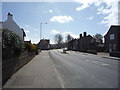
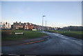
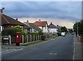
A149 Cromer Road, Sheringham
Heading out of Sheringham towards Cromer.
Image: © Robin Webster
Taken: 13 Aug 2018
0.04 miles
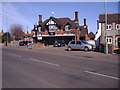
3
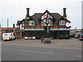
The Dunstable Arms, Sheringham
Pub on the A149 in the eastern outskirts of Sheringham.
Image: © G Laird
Taken: 31 Mar 2014
0.04 miles
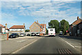
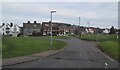
5
Beeston Common
On maps this road is shown as Brook St.
Image: © N Chadwick
Taken: 2 Jan 2014
0.05 miles
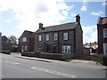
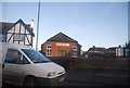
7
The Dunstable Arms Public House
The Dunstable Arms public house is located on the A149 Cromer road about a mile east of Sheringham
Image: © Mark Hobbs
Taken: 15 Mar 2009
0.06 miles
10
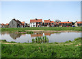
The dew pond on the green
Houses in Brook Road, viewed across the dew pond on the green.
Image: © Evelyn Simak
Taken: 5 May 2008
0.09 miles