IMAGES TAKEN NEAR TO
Beech Avenue, SHERINGHAM, NR26 8NS
Introduction
This page details the photographs taken nearby to Beech Avenue, NR26 8NS by members of the Geograph project.
The Geograph project started in 2005 with the aim of publishing, organising and preserving representative images for every square kilometre of Great Britain, Ireland and the Isle of Man.

There are currently over 7.5m images from over14,400 individuals and you can help contribute to the project by visiting https://www.geograph.org.uk
Image Map
Images are licensed for reuse under creativecommons.org/licenses/by-sa/2.0
Notes
- Clicking on the map will re-center to the selected point.
- The higher the marker number, the further away the image location is from the centre of the postcode.
Image Listing (18 Images Found)
Images are licensed for reuse under creativecommons.org/licenses/by-sa/2.0
Image
Details
Distance
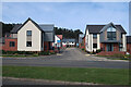
3
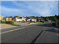
New houses on Seaview Crescent, Sheringham
Well over a kilometre inland.
Image: © Hugh Venables
Taken: 18 Aug 2017
0.10 miles
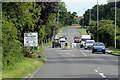
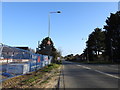
5
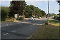
Entering Sheringham on Holway Road
Currently the edge of the town (on the west side of the road), but more houses are being built to the south.
Image: © Hugh Venables
Taken: 8 Aug 2020
0.14 miles
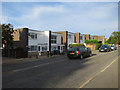
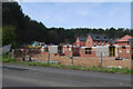
6

Expanding Sheringham
Extra block of houses on the southern edge.
Image: © Hugh Venables
Taken: 1 Jun 2021
0.14 miles
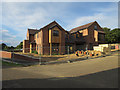
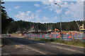
7
Repton Way
Ongoing expansion of Sheringham.
Image: © Hugh Venables
Taken: 14 Apr 2022
0.14 miles
8
House building on the edge of Sheringham
Image: © Hugh Venables
Taken: 14 Apr 2022
0.14 miles
9
New housing under construction, Holway Road
Extending Sheringham southwards.
Image: © Hugh Venables
Taken: 8 Aug 2020
0.15 miles
10
New housing estate off Holway Road, Sheringham
Image: © Adrian S Pye
Taken: 24 Mar 2019
0.15 miles