IMAGES TAKEN NEAR TO
Holt Road, SHERINGHAM, NR26 8NA
Introduction
This page details the photographs taken nearby to Holt Road, NR26 8NA by members of the Geograph project.
The Geograph project started in 2005 with the aim of publishing, organising and preserving representative images for every square kilometre of Great Britain, Ireland and the Isle of Man.

There are currently over 7.5m images from over14,400 individuals and you can help contribute to the project by visiting https://www.geograph.org.uk
Image Map
Images are licensed for reuse under creativecommons.org/licenses/by-sa/2.0
Notes
- Clicking on the map will re-center to the selected point.
- The higher the marker number, the further away the image location is from the centre of the postcode.
Image Listing (157 Images Found)
Images are licensed for reuse under creativecommons.org/licenses/by-sa/2.0
Image
Details
Distance
3
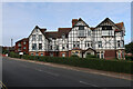
Sheringham Court
Flats for those over 55.
Image: © Hugh Venables
Taken: 13 Oct 2021
0.11 miles
5
OS Flush Bracket S0104
Further details found at http://www.bench-marks.org.uk/bm11938
Image: © Richard Neale
Taken: 1 May 2011
0.11 miles
6
OS Flush Bracket S0104
Further details found at http://www.bench-marks.org.uk/bm11938
Image: © Richard Neale
Taken: 1 May 2011
0.11 miles
7
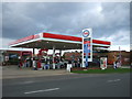
Service station on Weybourne Road, Sheringham
Showing position of Postbox No. NR26 2628.
Image: © JThomas
Taken: 30 Sep 2017
0.12 miles
8
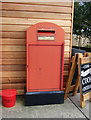
Elizabeth II postbox on, service station on Weybourne Road, Sheringham
Postbox No. NR26 2628.
Image: © JThomas
Taken: 30 Sep 2017
0.12 miles
9
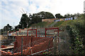
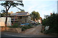
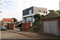
Building site on the side of Franklin Hill
Image: © Hugh Venables
Taken: 13 Oct 2021
0.13 miles
10
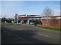
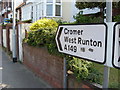
Petrol station, Sheringham
By the A149 on the way out of the town.
Image: © Hugh Venables
Taken: 27 Feb 2016
0.13 miles