IMAGES TAKEN NEAR TO
The Parishes, HOLT, NR25 7TD
Introduction
This page details the photographs taken nearby to The Parishes, NR25 7TD by members of the Geograph project.
The Geograph project started in 2005 with the aim of publishing, organising and preserving representative images for every square kilometre of Great Britain, Ireland and the Isle of Man.

There are currently over 7.5m images from over14,400 individuals and you can help contribute to the project by visiting https://www.geograph.org.uk
Image Map
Images are licensed for reuse under creativecommons.org/licenses/by-sa/2.0
Notes
- Clicking on the map will re-center to the selected point.
- The higher the marker number, the further away the image location is from the centre of the postcode.
Image Listing (201 Images Found)
Images are licensed for reuse under creativecommons.org/licenses/by-sa/2.0
Image
Details
Distance
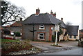
2

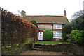
Thatched cottages
These attractive thatched cottages are situated beside The Street, a short distance west of the Ship Inn.
Image: © Evelyn Simak
Taken: 16 Nov 2007
0.03 miles
3
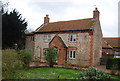
Flint built cottage
The dating suggests 17th century.
Image: © N Chadwick
Taken: 31 Dec 2013
0.03 miles

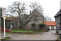
7

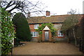
The Maltings Hotel, Weybourne
On The Street.
Image: © JThomas
Taken: 30 Sep 2017
0.05 miles

10
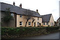
The Maltings Hotel
Closed at the present.
Image: © N Chadwick
Taken: 31 Dec 2013
0.05 miles