IMAGES TAKEN NEAR TO
Hilltop, HOLT, NR25 7SD
Introduction
This page details the photographs taken nearby to Hilltop, NR25 7SD by members of the Geograph project.
The Geograph project started in 2005 with the aim of publishing, organising and preserving representative images for every square kilometre of Great Britain, Ireland and the Isle of Man.

There are currently over 7.5m images from over14,400 individuals and you can help contribute to the project by visiting https://www.geograph.org.uk
Image Map
Images are licensed for reuse under creativecommons.org/licenses/by-sa/2.0
Notes
- Clicking on the map will re-center to the selected point.
- The higher the marker number, the further away the image location is from the centre of the postcode.
Image Listing (119 Images Found)
Images are licensed for reuse under creativecommons.org/licenses/by-sa/2.0
Image
Details
Distance
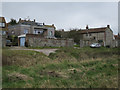
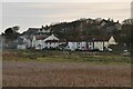
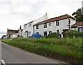
2
Old next to new
Contrasting styles of house next to each other on the edge of Cley.
Image: © Malcolm Neal
Taken: 9 Aug 2019
0.05 miles
5
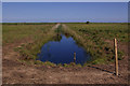
Drainage ditch, Cley Marshes
Cley Marshes are an important Norfolk Wildlife Trust reserve.
Image: © Ian Capper
Taken: 15 Aug 2008
0.07 miles
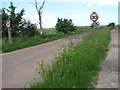
6
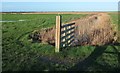
Channel, Cley Marshes
From a path alongside the A149, looking coastwards.
Image: © Derek Harper
Taken: 31 Dec 2015
0.07 miles
7
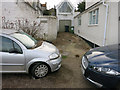
Flood debris, Cley next the Sea
The car is up the bank on the south side of the coast road, but was still flooded by the storm surge.
Image: © Hugh Venables
Taken: 8 Dec 2013
0.07 miles
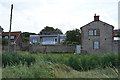
8
Houses on Coast Road, Cley Next The Sea
Image: © Roger Cornfoot
Taken: 20 Jun 2019
0.08 miles
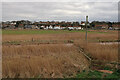
9
View east along the A149 (Coast Road)
The Cley marshes can be seen at left.
Image: © Evelyn Simak
Taken: 11 Jun 2008
0.08 miles