
IMAGES TAKEN NEAR TO
Station Road, HOLT, NR25 6BS
Introduction
This page details the photographs taken nearby to Station Road, NR25 6BS by members of the Geograph project.
The Geograph project started in 2005 with the aim of publishing, organising and preserving representative images for every square kilometre of Great Britain, Ireland and the Isle of Man.

There are currently over 7.5m images from over14,400 individuals and you can help contribute to the project by visiting https://www.geograph.org.uk
Image Map
Images are licensed for reuse under creativecommons.org/licenses/by-sa/2.0
Notes
- Clicking on the map will re-center to the selected point.
- The higher the marker number, the further away the image location is from the centre of the postcode.
Image Listing (420 Images Found)
Images are licensed for reuse under creativecommons.org/licenses/by-sa/2.0
Image
Details
Distance
1

Former "Gresham's" Building, Holt, Norfolk
This, the original school, was founded in 1555 by Sir John Gresham, a wealthy merchant and one time financial agent to Cardinal Wolsey. He also served as Lord Mayor of London. He was responsible for the conversion of the Manor House into a free Grammar School in 1562 following Henry VIII’s suppression of the monasteries. The school was created to educate 50 free scholars, i.e. boys of Holt and nearby villages. Not only did Gresham, a native of Holt and an alderman and citizen of London, endow the school but he also arranged for the management of the school to be vested in the Fishmongers' Company of London. The school survived the town’s Great Fire of 1708 which destroyed most of medieval Holt and then was extensively enlarged and refurbished in 1858. The main school transferred to its Cromer Road site in 1903. This building is now known as the ‘Old School House’ and currently serves as Gresham’s Pre-Prep (i.e. nursery) School.
Image: © David Hallam-Jones
Taken: 10 Aug 2018
0.01 miles
2

"Walk this way" at the start of Station Road
An appropriate invitation to the Holt Foot Clinic at the point where Market Place becomes Station Road. Incidentally, this road does not lead to the location of the present station but the old site, now overlaid by a small bypass. A close inspection of the lowest past of the red brick wall will reveal that it has been repaired more than once, presumably after vehicles had not "walked this way" but had rather inexpertly swung wide while driving into the narrow opening. Image is directly behind the photographer.
Image: © Zorba the Geek
Taken: 28 Jan 2009
0.03 miles
3

Cut Mark Old School House Market Place Holt
Image: © Monica Stagg
Taken: 10 Jul 2015
0.03 miles

5

The Railway Hotel, Holt Market Place
Originally built as a coaching inn in the 18th century, the Railway Tavern in Holt was formerly the Fighting Henry Public House. It is a grade II listed building (English Heritage Building ID: 223824 http://www.britishlistedbuildings.co.uk/en-223824-fighting-henry-public-house-holt-norfolk#.VeiYa3mFOHs British Listed Buildings).
Image: © David Dixon
Taken: 3 Aug 2015
0.03 miles

7

War Memorial, Holt
In the town square at Holt. The lovely 'Routemaster' bus provides a shuttle service to the North Norfolk Railway station, about a mile away.
Image: © John Lucas
Taken: 6 Sep 2006
0.04 miles
8
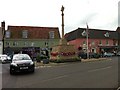
War Memorial, Holt
At the junction of Market Place and Station Road.
Image: © Dave Fergusson
Taken: 14 Aug 2012
0.04 miles
9

Holt War Memorial
Market Place at junction with Station Road. This is a Grade II listed building. The 19th century building behind the memorial is Gresham's Old School House which is now part of Gresham's pre-prep school.
Image: © Peter Holmes
Taken: 16 Jun 2015
0.04 miles
