
IMAGES TAKEN NEAR TO
St. Benedicts Street, NORWICH, NR2 4FG
Introduction
This page details the photographs taken nearby to St. Benedicts Street, NR2 4FG by members of the Geograph project.
The Geograph project started in 2005 with the aim of publishing, organising and preserving representative images for every square kilometre of Great Britain, Ireland and the Isle of Man.

There are currently over 7.5m images from over14,400 individuals and you can help contribute to the project by visiting https://www.geograph.org.uk
Image Map
Images are licensed for reuse under creativecommons.org/licenses/by-sa/2.0
Notes
- Clicking on the map will re-center to the selected point.
- The higher the marker number, the further away the image location is from the centre of the postcode.
Image Listing (5190 Images Found)
Images are licensed for reuse under creativecommons.org/licenses/by-sa/2.0
Image
Details
Distance
1
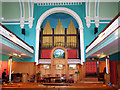
United Reformed church in Princes Street, Norwich
Princes Street Congregational Church was opened in 1819. The site used to be a yard of densely populated tenement houses grouped around a central courtyard. Within a short time the roof was found to be unsafe and alterations were made in 1828 and some buildings situated behind the church were modified and incorporated into the Church Rooms. The church was further altered and partially rebuilt in 1881 by Edward Boardman, a Deacon of the Church, and its present facade dates from this time. The roof was raised and a plasterwork ceiling installed. In 1927 the traditional box pews were replaced by the present pine pews with umbrella racks. For an exterior view see > https://www.geograph.org.uk/photo/5821185.
Image: © Evelyn Simak
Taken: 11 Sep 2010
0.00 miles
2
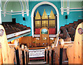
United Reformed church in Princes Street, Norwich
The view from the gallery. Princes Street Congregational Church was opened in 1819. The site used to be a yard of densely populated tenement houses grouped around a central courtyard. Within a short time the roof was found to be unsafe and alterations were made in 1828 and some buildings situated behind the church were modified and incorporated into the Church Rooms. The church was further altered and partially rebuilt in 1881 by Edward Boardman, a Deacon of the Church, and its present facade dates from this time. The roof was raised and a plasterwork ceiling installed. In 1927 the traditional box pews were replaced by the present pine pews with umbrella racks. For an exterior view see > https://www.geograph.org.uk/photo/5821185.
Image: © Evelyn Simak
Taken: 11 Sep 2010
0.00 miles
3
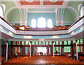
United Reformed church in Princes Street, Norwich
Princes Street Congregational Church was opened in 1819. The site used to be a yard of densely populated tenement houses grouped around a central courtyard. Within a short time the roof was found to be unsafe and alterations were made in 1828 and some buildings situated behind the church were modified and incorporated into the Church Rooms. The church was further altered and partially rebuilt in 1881 by Edward Boardman, a Deacon of the Church, and its present facade dates from this time. The roof was raised and a plasterwork ceiling installed. In 1927 the traditional box pews were replaced by the present pine pews with umbrella racks. For an exterior view see > https://www.geograph.org.uk/photo/5821185.
Image: © Evelyn Simak
Taken: 11 Sep 2010
0.00 miles
4

Oval-shaped General Post Office manhole cover
For a wider view of this location see https://www.geograph.org.uk/photo/6253094.
The General Post Office (GPO) was officially established in England in 1660 by Charles II and it eventually grew to combine the functions of state postal system and telecommunications carrier. Similar General Post Offices were established across the British Empire. In 1969 the GPO was abolished and the assets transferred to The Post Office, changing it from a Department of State to a statutory corporation. In 1980, the telecommunications and postal sides were split prior to British Telecommunications' conversion into a totally separate publicly owned corporation the following year as a result of the British Telecommunications Act 1981.
Originally, the GPO was a monopoly covering the despatch of items from a specific sender to a specific receiver, which was to be of great importance when new forms of communication were invented. The postal service was known as the Royal Mail because it was built on the distribution system for royal and government documents. In 1661 the office of Postmaster General was created to oversee the GPO. For more information go to: https://en.wikipedia.org/wiki/General_Post_Office
Image: © Evelyn Simak
Taken: 31 Aug 2019
0.01 miles
5

Detail of 8-10 Bank Street, Norwich
A shopfront with panelled Corinthian pilasters, probably late Victorian.
Image: © Stephen Richards
Taken: 16 Jun 2013
0.01 miles
6

8/10 Bank Street - Athena Games
The building used to be the Bank Tavern until the pub's closure in 1965. The first recorded licensee was Thomas Buttifant in 1836.
Image: © Evelyn Simak
Taken: 14 Aug 2018
0.01 miles
7

View west along Bank Street
The building at left is the Royal Business Centre. Part of former Barclays Bank on Redwell Street can be seen in the background.
Image: © Evelyn Simak
Taken: 14 Aug 2018
0.01 miles

9
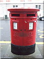
Double aperture Elizabeth II postbox on Bank Plain, Norwich
Postboxes No. NR2 239 and NR2 240.
See Image] for context.
Image: © JThomas
Taken: 16 Sep 2017
0.01 miles
10
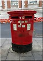
Double aperture Elizabeth II postbox on Bank Plain
Postbox No. NR2 239 and Postbox No. NR2 240.
Image: © JThomas
Taken: 6 Oct 2023
0.02 miles