IMAGES TAKEN NEAR TO
St. Andrews Street, NORWICH, NR2 4AT
Introduction
This page details the photographs taken nearby to St. Andrews Street, NR2 4AT by members of the Geograph project.
The Geograph project started in 2005 with the aim of publishing, organising and preserving representative images for every square kilometre of Great Britain, Ireland and the Isle of Man.

There are currently over 7.5m images from over14,400 individuals and you can help contribute to the project by visiting https://www.geograph.org.uk
Image Map
Images are licensed for reuse under creativecommons.org/licenses/by-sa/2.0
Notes
- Clicking on the map will re-center to the selected point.
- The higher the marker number, the further away the image location is from the centre of the postcode.
Image Listing (5700 Images Found)
Images are licensed for reuse under creativecommons.org/licenses/by-sa/2.0
Image
Details
Distance
1
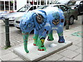
Go Elephants, Mic Live
Mic Live by Community Group Young People of the NR5 Project working with Mik Richardson and sponsored by NR5 Project with support of Heritage Lottery Fund is one of the fifty three elephants that forms part of the Go Elephants trail across Norwich from 23 June to the 31 Aug 2008. The elephants will be sold at a charity auction in aid of CLIC Sargent and The Born Free Foundation. This is number 28 of 47 that I have managed to photograph.
Image: © Keith Evans
Taken: 26 Aug 2008
0.00 miles
2
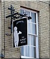
The Rumsey Wells - pub sign
For a wider view of this location and some information see > http://www.geograph.org.uk/photo/5866883.
Image: © Evelyn Simak
Taken: 6 Aug 2018
0.01 miles
3
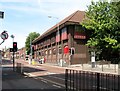
St Andrews Street - The Telephone Exchange
The Telephone Exchange was built in 1938 on the site of the demolished Parsonage.
Image: © Evelyn Simak
Taken: 6 Aug 2018
0.01 miles
4

The Telephone Exchange in St Andrews Street
For another view of this location and some information see > http://www.geograph.org.uk/photo/5866870.
Image: © Evelyn Simak
Taken: 6 Aug 2018
0.01 miles

6
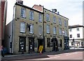
2-4 St Andrews Street - The Rumsey Wells public house
This pub was known as 'The Shrub House' in 1979, and re-opened in 1984 as 'Blueberries'. From 1985-1989 it was known as the 'Rumsey Wells' but from 1989 onwards it became the 'St Andrews Tavern'. In October 2008 it reverted back to 'Rumsey Wells'. The building dates from the early 19th century and is Grade 2 listed.
Image: © Evelyn Simak
Taken: 6 Aug 2018
0.01 miles
7

2-4 St Andrews Street - The Rumsey Wells public house
This pub was known as 'The Shrub House' in 1979, and re-opened in 1984 as 'Blueberries'. From 1985-1989 it was known as the 'Rumsey Wells' but from 1989 onwards it became the 'St Andrews Tavern'. In October 2008 it reverted back to 'Rumsey Wells'. The building dates from the early 19th century and is Grade 2 listed.
Image: © Evelyn Simak
Taken: 6 Aug 2018
0.01 miles
8
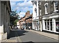
Exchange Street past Jarrold
Exchange Street was once known as Old Post Office Street and was the first new road built in the city since the Norman period. For some time it as also known as Museum Street before it became Exchange Street, named after the corn exchange building which has since been demolished.
Image: © Evelyn Simak
Taken: 18 Aug 2019
0.01 miles
9
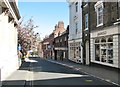
View north along Exchange Street
From the junction with Lobster Lane. The city's streets and lanes are usually teeming with tourists and shoppers, but with all pubs, restaurants and non-essential shops currently being closed due to the Coronavirus pandemic, most people are adhering to the lockdown rules and stay at home.
Image: © Evelyn Simak
Taken: 19 Apr 2020
0.01 miles