IMAGES TAKEN NEAR TO
Canon Marcon Way, MELTON CONSTABLE, NR24 2RX
Introduction
This page details the photographs taken nearby to Canon Marcon Way, NR24 2RX by members of the Geograph project.
The Geograph project started in 2005 with the aim of publishing, organising and preserving representative images for every square kilometre of Great Britain, Ireland and the Isle of Man.

There are currently over 7.5m images from over14,400 individuals and you can help contribute to the project by visiting https://www.geograph.org.uk
Image Map
Images are licensed for reuse under creativecommons.org/licenses/by-sa/2.0
Notes
- Clicking on the map will re-center to the selected point.
- The higher the marker number, the further away the image location is from the centre of the postcode.
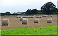
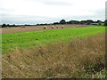
Image Listing (26 Images Found)
Images are licensed for reuse under creativecommons.org/licenses/by-sa/2.0
Image
Details
Distance
3
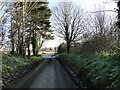
Leaving Rectory Road Edgefield and joining the B1149
Image: © Adrian S Pye
Taken: 30 Dec 2014
0.14 miles
4
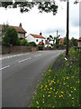
View north along the B1149 (Norwich Road)
Through Edgefield.
Image: © Evelyn Simak
Taken: 9 Jul 2008
0.16 miles
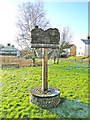
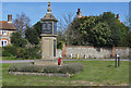
7
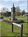
War memorial, Edgefield
View towards the village pond.
Image: © Pauline E
Taken: 7 May 2013
0.23 miles
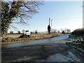
8
War memorial, Edgefield
Near the village green on Norwich Road.
Image: © Pauline E
Taken: 7 May 2013
0.23 miles
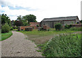
9
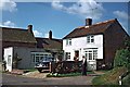
Bluebell Cottage, Edgefield Green
Bluebell Cottage, Edgefield Green, near Holt, Norfolk, opposite the duck pond.
Image: © Christine Matthews
Taken: Unknown
0.23 miles