IMAGES TAKEN NEAR TO
Mill Lane, MELTON CONSTABLE, NR24 2QA

Introduction

This page details the photographs taken nearby to Mill Lane, NR24 2QA by members of the Geograph project.

The Geograph project started in 2005 with the aim of publishing, organising and preserving representative images for every square kilometre of Great Britain, Ireland and the Isle of Man.

There are currently over 7.5m images from over14,400 individuals and you can help contribute to the project by visiting https://www.geograph.org.uk

Image Map


Images are licensed for reuse under creativecommons.org/licenses/by-sa/2.0
Notes
  • Clicking on the map will re-center to the selected point.
  • The higher the marker number, the further away the image location is from the centre of the postcode.

Image Listing (9 Images Found)

Images are licensed for reuse under creativecommons.org/licenses/by-sa/2.0
Image
Details
Distance
1
Farm track meets bridleway
The bridleway leading to Celia's Wood and The Tower branches off to the northwest.
Image: © Evelyn Simak Taken: 9 Sep 2007
0.04 miles
2
View towards Celia's Wood from bridleway
The outline of the hedgerow and a few solitary trees mark the course of the path.
Image: © Evelyn Simak Taken: 9 Sep 2007
0.10 miles
3
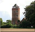
Belvue Tower, Briningham
This attractive 4-storey high brick tower is a Grade II listed building. Originally built for use as a look-out tower it was later converted into a windmill and then into a folly. The lower stage is believed to date from the 16th century. The brick refacing was carried out when the building was converted into a smock windmill by Sir Jacob Astley 1st Bart, in the 18th century. The mill was replaced by the 4th Bart in 1781 when upper floors were added to make 5 domestic storeys, the lower stages of which are octagonal and the upper circular, topped by a battlemented parapet and stack. The attic with hipped tiled roof above the parapet is C20. A house was added in the 20th century.
Image: © Evelyn Simak Taken: 28 Aug 2011
0.12 miles
4
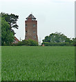
Belle Vue Tower near Melton Constable
When built in 1721, a feature of the Melton estate. The upper stages were rebuilt in 1781. Grade II listed. Closer view and more info Image
Image: © Stephen Richards Taken: 18 Jun 2013
0.13 miles
5
Belvue Plantation and Belvue Tower, Briningham
For a more detailed view of and information about the Grade II listed tower see > http://www.geograph.org.uk/photo/2576340.
Image: © Evelyn Simak Taken: 28 Aug 2011
0.14 miles
6
Mill Lane, Briningham
Image: © Evelyn Simak Taken: 28 Aug 2011
0.16 miles
7
Hawthorn hedge beside Mill Lane, Briningham
Image: © Evelyn Simak Taken: 28 Aug 2011
0.19 miles
8
Harvested field north of Mill Lane, Briningham
Image: © Evelyn Simak Taken: 28 Aug 2011
0.22 miles
9
Field boundary and track to woodland near The Street
Image: © Evelyn Simak Taken: 9 Sep 2007
0.23 miles