IMAGES TAKEN NEAR TO
Briston Road, MELTON CONSTABLE, NR24 2EN
Introduction
This page details the photographs taken nearby to Briston Road, NR24 2EN by members of the Geograph project.
The Geograph project started in 2005 with the aim of publishing, organising and preserving representative images for every square kilometre of Great Britain, Ireland and the Isle of Man.

There are currently over 7.5m images from over14,400 individuals and you can help contribute to the project by visiting https://www.geograph.org.uk
Image Map
Images are licensed for reuse under creativecommons.org/licenses/by-sa/2.0
Notes
- Clicking on the map will re-center to the selected point.
- The higher the marker number, the further away the image location is from the centre of the postcode.
Image Listing (11 Images Found)
Images are licensed for reuse under creativecommons.org/licenses/by-sa/2.0
Image
Details
Distance
1
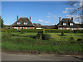
Thatched Cottages
Marked on the map as such, near Sebastopol.
Image: © Hugh Venables
Taken: 17 Apr 2016
0.02 miles
2
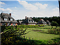
A row of beautiful thatched cottages
These trim cottages, with their immaculate gardens, presumably belong to the neighbouring large estate (Stody Lodge?) containing the wonderfully named Sebastopol (Woods?)
Image: © Zorba the Geek
Taken: 3 Aug 2007
0.02 miles
3
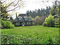
On the edge of Sebastopol
Attractive cottage beside Holt Road; the woodland seen in the background is called Sebastopol and belongs to the Stody Estate.
Image: © Evelyn Simak
Taken: 3 May 2008
0.03 miles
4
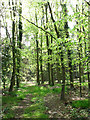
A woodland called Sebastopol
Looking in, from beside Holt Road.
Image: © Evelyn Simak
Taken: 3 May 2008
0.09 miles
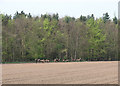
6
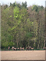
A herd of red deer
Hinds, gathered at > Image, viewed across field beside Holt Road.
Image: © Evelyn Simak
Taken: 3 May 2008
0.15 miles
7
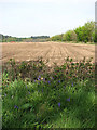
View towards Oakhill Plantation
The view direction is norwesterly, across a field beside Holt Road. Bluebells are growing by the roadside.
Image: © Evelyn Simak
Taken: 3 May 2008
0.17 miles
8
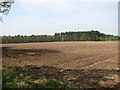
The eastern edge of Lodge Plantation
Viewed across field beside Holt Road.
Image: © Evelyn Simak
Taken: 3 May 2008
0.19 miles
9
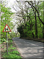
Holt Road past Stody Lodge
Lodge Plantation is at left (west); the section on the other side of the road is called Sebastopol.
Image: © Evelyn Simak
Taken: 3 May 2008
0.20 miles
10
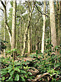
On the other side of the rhododendron hedge
View into Lodge Plantation, on the other (western) side of Holt Road, from driveway > http://www.geograph.org.uk/photo/788398. Lodge Plantation forms part of the Stody Estate and is a private woodland. See also http://www.geograph.org.uk/photo/787304 and http://www.geograph.org.uk/photo/787358
Image: © Evelyn Simak
Taken: 4 May 2008
0.21 miles