IMAGES TAKEN NEAR TO
Dereham Road, MELTON CONSTABLE, NR24 2EA
Introduction
This page details the photographs taken nearby to Dereham Road, NR24 2EA by members of the Geograph project.
The Geograph project started in 2005 with the aim of publishing, organising and preserving representative images for every square kilometre of Great Britain, Ireland and the Isle of Man.

There are currently over 7.5m images from over14,400 individuals and you can help contribute to the project by visiting https://www.geograph.org.uk
Image Map
Images are licensed for reuse under creativecommons.org/licenses/by-sa/2.0
Notes
- Clicking on the map will re-center to the selected point.
- The higher the marker number, the further away the image location is from the centre of the postcode.
Image Listing (15 Images Found)
Images are licensed for reuse under creativecommons.org/licenses/by-sa/2.0
Image
Details
Distance
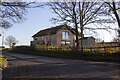
2
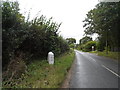
To Dereham 15
Old milestone on the A.148 near to Brinton, Norfolk. For close up view see http://www.geograph.org.uk/photo/1639874
Image: © Keith Evans
Taken: 29 Dec 2009
0.10 miles
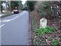
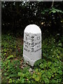
3
Old Milestone by the B1110, The Street, Brinton parish
Carved stone post by the B1110, in parish of BRINTON (NORTH NORFOLK District), 20yds South of house called "Milestone" on East side, on narrow verge under hedge, on West side of road. Erected by an unknown authority in the 19th century.
Inscription reads:-
: 3 / MILES / TO / HOLT : : BRINTON : : 15 / MILES / TO / DEREHAM :
Norfolk HER.
NHER Number: 56510 https://www.heritagegateway.org.uk/Gateway/Results_Single.aspx?uid=MNF62920&resourceID=1002
Milestone Society National ID: NO_HD03
Image: © CW Haines
Taken: 3 Dec 2014
0.11 miles
4
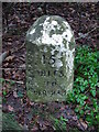
Old Milestone
Old milestone on the A.148 near to Brinton, Norfolk. For overall view see http://www.geograph.org.uk/photo/1639873
Image: © Keith Evans
Taken: 29 Dec 2009
0.12 miles
5
Milestone on B1110
3 miles to Holt, 15 miles to Dereham. See for a close-up.
Image: © Bikeboy
Taken: 18 Aug 2014
0.12 miles
6
Milestone on B1110 (close up)
See http://www.geograph.org.uk/photo/4129624 for a wider view. It has clearly been cleaned or repainted since Keith Evans' visit in 2009.
Image: © Bikeboy
Taken: 18 Aug 2014
0.12 miles
7
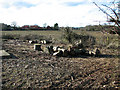
Segments of a felled tree by electricity substation
Image: © Evelyn Simak
Taken: 14 Feb 2011
0.20 miles
8
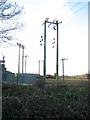
Electricity poles by substation south of Thornage
Image: © Evelyn Simak
Taken: 14 Feb 2011
0.21 miles
9
Old railway bridge buttresses
At the bottom of the dip, cut for the road to pass under the Melton Constable to Holt railway line, remain the two buttresses of the bridge, the top of which was demolished along with the track. Thank you Dr. Beeching. http://www.geograph.org.uk/photo/2270673
Image: © Adrian S Pye
Taken: 23 Jul 2015
0.22 miles
10
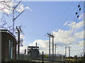
Stody electricity substation
Stody, Norfolk
Image: © Adrian S Pye
Taken: 14 Feb 2011
0.22 miles