IMAGES TAKEN NEAR TO
Plumstead Road, MELTON CONSTABLE, NR24 2AQ
Introduction
This page details the photographs taken nearby to Plumstead Road, NR24 2AQ by members of the Geograph project.
The Geograph project started in 2005 with the aim of publishing, organising and preserving representative images for every square kilometre of Great Britain, Ireland and the Isle of Man.

There are currently over 7.5m images from over14,400 individuals and you can help contribute to the project by visiting https://www.geograph.org.uk
Image Map
Images are licensed for reuse under creativecommons.org/licenses/by-sa/2.0
Notes
- Clicking on the map will re-center to the selected point.
- The higher the marker number, the further away the image location is from the centre of the postcode.
Image Listing (14 Images Found)
Images are licensed for reuse under creativecommons.org/licenses/by-sa/2.0
Image
Details
Distance
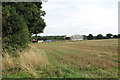
1
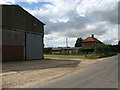
Farm shed and cottages on Plumstead Road
Image: © Evelyn Simak
Taken: 2 Sep 2007
0.03 miles
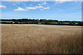
2
Sheds by Wood Farm Cottages, Edgefield
Image: © Evelyn Simak
Taken: 21 Sep 2013
0.07 miles
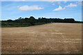
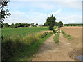
5
Drive to Wood Farm - the farm can be seen in the distance
Image: © Evelyn Simak
Taken: 2 Sep 2007
0.10 miles
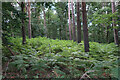
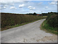
7
East on Plumstead Road, approaching Little Wood
Image: © Evelyn Simak
Taken: 2 Sep 2007
0.15 miles