IMAGES TAKEN NEAR TO
Wheatley Road, NORWICH, NR2 3UQ
Introduction
This page details the photographs taken nearby to Wheatley Road, NR2 3UQ by members of the Geograph project.
The Geograph project started in 2005 with the aim of publishing, organising and preserving representative images for every square kilometre of Great Britain, Ireland and the Isle of Man.

There are currently over 7.5m images from over14,400 individuals and you can help contribute to the project by visiting https://www.geograph.org.uk
Image Map
Images are licensed for reuse under creativecommons.org/licenses/by-sa/2.0
Notes
- Clicking on the map will re-center to the selected point.
- The higher the marker number, the further away the image location is from the centre of the postcode.
Image Listing (58 Images Found)
Images are licensed for reuse under creativecommons.org/licenses/by-sa/2.0
Image
Details
Distance
1
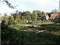
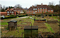
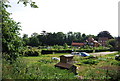
Allotments, Hellesdon
On the edge of busy Sweetbriar Road, part of the Outer Ring Road.
Image: © Katy Walters
Taken: 17 Nov 2005
0.01 miles
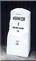
4
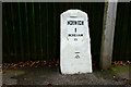
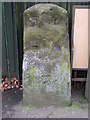
Milestone, Dereham Road, Norwich
Now refurbished, and back to its former glory.
Image: © Peter Trimming
Taken: 21 Feb 2013
0.06 miles
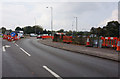
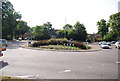
5
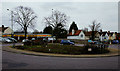
Roundabout on the A140, Norwich
The junction with Dereham Road, a little more than a mile out of Norwich.
Image: © Peter Trimming
Taken: 21 Feb 2013
0.07 miles
6
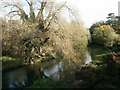
River Wensum from Sweetbriar Road
Looking east (downstream) towards the city.
Image: © Katy Walters
Taken: 17 Nov 2005
0.07 miles
7
Allotments Near Norwich
On the western outskirts of Norwich, near the junction of the A140 and A1074.
Image: © Peter Trimming
Taken: 21 Feb 2013
0.07 miles
8
Old Milestone
Old milestone on what would have been the A47 Dereham Road Norwich, Norfolk sadly this one has lost it cast iron plaque. The wording would have said Norwich 1 Dereham 15 for overall view see http://www.geograph.org.uk/photo/1178825
Image: © Keith Evans
Taken: 25 Feb 2009
0.10 miles
10
Old Milestone by the A1074, Dereham Road, Norwich parish
Metal plate attached to stone post by the A1074, in parish of NORWICH (NORWICH District), Dereham Road, by No.377, West of junction with Waterworks Road, in pavement against railings, on North side of road. Joseph Stanley iron plate (remade), erected by the Norwich & Swaffham turnpike trust in the 19th century.
Inscription reads:-
NORWICH
1
DEREHAM
15
Carved benchmark on lower mid front.
Norfolk HER.
NHER Number: 56385 https://www.heritagegateway.org.uk/Gateway/Results_Single.aspx?uid=MNF62791&resourceID=1002
Milestone Society National ID: NO_NSM01.
Image: © CW Haines
Taken: 26 Nov 2001
0.11 miles