IMAGES TAKEN NEAR TO
Market Lane, WELLS-NEXT-THE-SEA, NR23 1RB
Introduction
This page details the photographs taken nearby to Market Lane, NR23 1RB by members of the Geograph project.
The Geograph project started in 2005 with the aim of publishing, organising and preserving representative images for every square kilometre of Great Britain, Ireland and the Isle of Man.

There are currently over 7.5m images from over14,400 individuals and you can help contribute to the project by visiting https://www.geograph.org.uk
Image Map
Images are licensed for reuse under creativecommons.org/licenses/by-sa/2.0
Notes
- Clicking on the map will re-center to the selected point.
- The higher the marker number, the further away the image location is from the centre of the postcode.
Image Listing (145 Images Found)
Images are licensed for reuse under creativecommons.org/licenses/by-sa/2.0
Image
Details
Distance
4
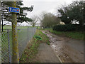
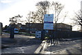
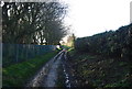
Market Lane
Leaving Wells-next-the-Sea to the south.
Image: © Hugh Venables
Taken: 31 Dec 2017
0.06 miles
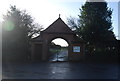
5
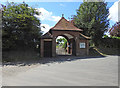
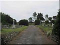
The entrance gate to Wells-next-the-Sea cemetery
Image: © Adrian S Pye
Taken: 27 May 2019
0.06 miles
7
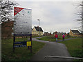
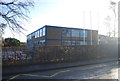
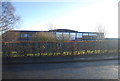
Staithe Place
Expanding Wells-next-the-Sea to the south.
Image: © Hugh Venables
Taken: 31 Dec 2017
0.07 miles
9
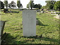
Grave of a Sailor of the Second World War
The body was found on the beach at Wells-next-the-Sea in September 1940.
Behind his grave is the expanse of Wells cemetery.
There are 16 named War Graves in the cemetery plus this Sailor of the Royal Navy and an unknown Airman.
Image: © Adrian S Pye
Taken: 25 Oct 2016
0.09 miles