IMAGES TAKEN NEAR TO
Northfield Avenue, WELLS-NEXT-THE-SEA, NR23 1LL
Introduction
This page details the photographs taken nearby to Northfield Avenue, NR23 1LL by members of the Geograph project.
The Geograph project started in 2005 with the aim of publishing, organising and preserving representative images for every square kilometre of Great Britain, Ireland and the Isle of Man.

There are currently over 7.5m images from over14,400 individuals and you can help contribute to the project by visiting https://www.geograph.org.uk
Image Map
Images are licensed for reuse under creativecommons.org/licenses/by-sa/2.0
Notes
- Clicking on the map will re-center to the selected point.
- The higher the marker number, the further away the image location is from the centre of the postcode.
Image Listing (598 Images Found)
Images are licensed for reuse under creativecommons.org/licenses/by-sa/2.0
Image
Details
Distance
1
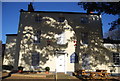
Cut Mark Eastdene North Field Lane Wells Next The Sea
Image: © Monica Stagg
Taken: 7 Jul 2015
0.05 miles
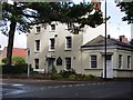
2
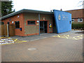
New Wells Police Station
The new, rather colourful patrol base for Norfolk Constabulary at Wells. The previous Police Station built in 1962 was demolished and the grounds are being developed as a patrol office and bungalows.
Image: © Bill Sibley
Taken: 11 Feb 2009
0.06 miles
4
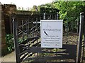
Artistic fence at entrance to Scrira Offshore Energy, Polka Road, Wells
This is at the end of the public footpath called School Alley, the sign for which can be seen in the background.
Image: © John Brightley
Taken: 5 May 2012
0.09 miles
5
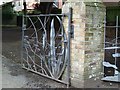
Sculptural metal gate at entrance to Scrira Offshore Energy
This is the entrance gate to the offices of Scrira Offshore Energy who are operators of the Sheringham Shoal Offshore Wind Farm, and the metalwork seems to represent a shoal of fish.
Image: © John Brightley
Taken: 5 May 2012
0.09 miles
6
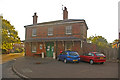
The Old Station, Wells-next-the Sea
Opened in 1857 as the terminus of the Wells & Fakenham Railway, later part of the Great Eastern Railway. From 1866 it also served the West Norfolk Junction Railway from Heacham (between Kings Lynn and Hunstanton). It closed in 1964, and is now a pottery/bookshop. For a closeup of the Victorian postbox visible behind the blue car, see Image
Image: © Ian Capper
Taken: 14 Aug 2008
0.09 miles
7
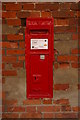
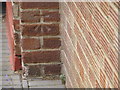
Victorian postbox, Wells-next-the-Sea
In the wall of the Old Station (see Image).
Image: © Ian Capper
Taken: 14 Aug 2008
0.09 miles
8
Wells-next-the-Sea railway station (site), Norfolk
Opened in 1857 by the Wells & Fakenham Railway, later part of the Great Eastern Railway, this terminus station closed to passengers in 1964.
Forecourt. The former platform area behind the building had become a small industrial estate when this image was taken.
Image: © Nigel Thompson
Taken: 11 Sep 2014
0.09 miles
9
The Lifeboat B&B, Wells next the Sea
On the corner of Station Road and Polka Road.
Image: © John Brightley
Taken: 5 May 2012
0.10 miles