IMAGES TAKEN NEAR TO
East End, WELLS-NEXT-THE-SEA, NR23 1LE
Introduction
This page details the photographs taken nearby to East End, NR23 1LE by members of the Geograph project.
The Geograph project started in 2005 with the aim of publishing, organising and preserving representative images for every square kilometre of Great Britain, Ireland and the Isle of Man.

There are currently over 7.5m images from over14,400 individuals and you can help contribute to the project by visiting https://www.geograph.org.uk
Image Map
Images are licensed for reuse under creativecommons.org/licenses/by-sa/2.0
Notes
- Clicking on the map will re-center to the selected point.
- The higher the marker number, the further away the image location is from the centre of the postcode.
Image Listing (268 Images Found)
Images are licensed for reuse under creativecommons.org/licenses/by-sa/2.0
Image
Details
Distance
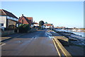
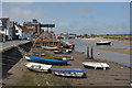
3
Boats on Stonemeal Creek at Wells-next-the-Sea
Image: © Mat Fascione
Taken: 15 Sep 2017
0.02 miles
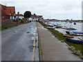
4

Slipway, Wells harbour
Tidal creek pictured just as the tide starts to come in.
Image: © Pauline E
Taken: 17 Sep 2012
0.02 miles
6
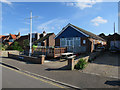
Wells Sailing Club
On East Quay, Wells-next-the-Sea.
Image: © Hugh Venables
Taken: 11 Sep 2015
0.02 miles
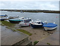
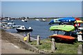
7

East towards the shipwrights at Wells-next-the-Sea
Here is the view east at Wells as the tide begins to make. Some of the buildings show that typical flint build of the area.
Image: © Ant Basterfield
Taken: 30 Jun 2016
0.02 miles
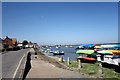
9
Wells Harbour
Viewed from the East Quay.
Image: © Peter Jeffery
Taken: 21 May 2018
0.03 miles
10
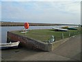
Wells-Next-The-Sea, life buoy
On the coastal path beyond the village centre.
Image: © Steve Fareham
Taken: 10 Mar 2012
0.03 miles