IMAGES TAKEN NEAR TO
Polka Road, WELLS-NEXT-THE-SEA, NR23 1JG
Introduction
This page details the photographs taken nearby to Polka Road, NR23 1JG by members of the Geograph project.
The Geograph project started in 2005 with the aim of publishing, organising and preserving representative images for every square kilometre of Great Britain, Ireland and the Isle of Man.

There are currently over 7.5m images from over14,400 individuals and you can help contribute to the project by visiting https://www.geograph.org.uk
Image Map
Images are licensed for reuse under creativecommons.org/licenses/by-sa/2.0
Notes
- Clicking on the map will re-center to the selected point.
- The higher the marker number, the further away the image location is from the centre of the postcode.
Image Listing (160 Images Found)
Images are licensed for reuse under creativecommons.org/licenses/by-sa/2.0
Image
Details
Distance
1

Wells-next-the-Sea town sign
This sign was erected by the Women’s Institute to celebrate their centenary, and supplements the one erected by the Carnival Committee at the top of Two Furlong Hill https://www.geograph.org.uk/photo/6707624 which is all about the sea. This sign depicts a heron, fish, bulrushes and pine trees and is located in an ornamental feature in Bluebell Gardens. https://www.geograph.org.uk/photo/6815228
Image: © Adrian S Pye
Taken: 20 Apr 2021
0.06 miles
2
Wells-next-the-Sea town sign
This sign was erected by the Women’s Institute to celebrate their centenary, and supplements the one erected by the Carnival Committee at the top of Two Furlong Hill https://www.geograph.org.uk/photo/6707624 which is all about the sea. This sign depicts a heron, fish, bulrushes and pine trees and is located in an ornamental feature in Bluebell Gardens. https://www.geograph.org.uk/photo/6815227
Image: © Adrian S Pye
Taken: 20 Apr 2021
0.06 miles
4
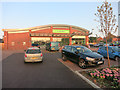
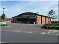
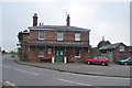
Co-operative supermarket, Wells-next-the-Sea
A new co-op in Wells, a welcome additional shop on the coast.
Image: © Hugh Venables
Taken: 3 Sep 2014
0.08 miles
7
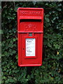
Elizabeth II postbox on Warham Road, Wells-next-the-Sea
Postbox No. NR23 2309.
See Image] for context.
Image: © JThomas
Taken: 30 Sep 2017
0.09 miles
8
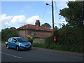
Cottage on Warham Road, Wells-next-the-Sea
Showing position of Postbox No. NR22 2201.
See Image] for postbox.
Image: © JThomas
Taken: 30 Sep 2017
0.09 miles
9
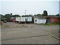
Wells-next-the-Sea railway station (site), Norfolk
Opened in 1857 by the Wells & Fakenham Railway, later part of the Great Eastern Railway, this terminus station closed to passengers in 1964.
View north west along the former platform towards the buffers. The chimneys of the station building can be seen above the industrial units.
Image: © Nigel Thompson
Taken: 11 Sep 2014
0.10 miles
10
Wells On Sea Railway Station
A front view of the station, now a book store and pottery. This is the only part to survive.
The station was the northern terminus for the branch from Wymondham and also the terminus of the Hunstanton to Wells Branch. A small branch also left for the harbour, curving to the west of the town. The line to Hunstanton via Holkham and Burnham Market closed after damage from the 1953 floods. Several bridges and embankments still survive in the area. The Whole section from Fakenham to here closed under Dr Beeching in 1964. The area of the platforms and engine shed is now an industrial estate.
See a 1960s view http://www.remembernorfolk.org/viewlarge.aspx?GI=23&MI=51000230315
Image: © Ashley Dace
Taken: 15 Apr 2010
0.10 miles