IMAGES TAKEN NEAR TO
Bathurst Road, NORWICH, NR2 2PP
Introduction
This page details the photographs taken nearby to Bathurst Road, NR2 2PP by members of the Geograph project.
The Geograph project started in 2005 with the aim of publishing, organising and preserving representative images for every square kilometre of Great Britain, Ireland and the Isle of Man.

There are currently over 7.5m images from over14,400 individuals and you can help contribute to the project by visiting https://www.geograph.org.uk
Image Map
Images are licensed for reuse under creativecommons.org/licenses/by-sa/2.0
Notes
- Clicking on the map will re-center to the selected point.
- The higher the marker number, the further away the image location is from the centre of the postcode.
Image Listing (550 Images Found)
Images are licensed for reuse under creativecommons.org/licenses/by-sa/2.0
Image
Details
Distance
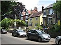
1
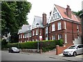
50-54 Mill Hill Road
Some of the flats in this building are currently to let.
Image: © Evelyn Simak
Taken: 15 Jun 2018
0.03 miles
2
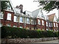
50-54 Mill Hill Road
See > http://www.geograph.org.uk/photo/5809745 for another view.
Image: © Evelyn Simak
Taken: 15 Jun 2018
0.03 miles
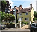
3
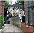
60 Mill Hill Road - Portland Terrace (rear)
This would seem to be a summer house to the rear of Portland Terrace > https://www.geograph.org.uk/photo/5809731. Many houses in this road are included on the local conservation area list for their contributions to the local scene or for local historical associations.
Image: © Evelyn Simak
Taken: 15 Jun 2018
0.03 miles
4
58 and 58a Mill Hill Road
Many houses in this road are included on the local conservation area list for their contributions to the local scene or for local historical associations.
Image: © Evelyn Simak
Taken: 15 Jun 2018
0.04 miles
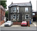
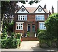
5
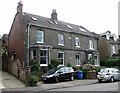
60 Mill Hill Road - Portland Terrace
Many houses in this road are included on the local conservation area list for their contributions to the local scene or for local historical associations.
Image: © Evelyn Simak
Taken: 15 Jun 2018
0.04 miles
6
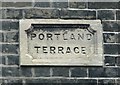
60 Mill Hill Road - Portland Terrace (name plaque)
For a view of this location see > http://www.geograph.org.uk/photo/5809731.
Image: © Evelyn Simak
Taken: 15 Jun 2018
0.04 miles
7
32 Mill Hill Road
Many houses in this road are included on the local conservation area list for their contributions to the local scene or for local historical associations.
Image: © Evelyn Simak
Taken: 15 Jun 2018
0.05 miles
9
28 and 32 Mill Hill Road
Many houses in this road are included on the local conservation area list for their contributions to the local scene or for local historical associations.
Image: © Evelyn Simak
Taken: 15 Jun 2018
0.06 miles
10
28 Mill Hill Road
Many houses in this road are included on the local conservation area list for their contributions to the local scene or for local historical associations.
Image: © Evelyn Simak
Taken: 15 Jun 2018
0.06 miles