IMAGES TAKEN NEAR TO
Haymarket, NORWICH, NR2 1QL
Introduction
This page details the photographs taken nearby to Haymarket, NR2 1QL by members of the Geograph project.
The Geograph project started in 2005 with the aim of publishing, organising and preserving representative images for every square kilometre of Great Britain, Ireland and the Isle of Man.

There are currently over 7.5m images from over14,400 individuals and you can help contribute to the project by visiting https://www.geograph.org.uk
Image Map
Images are licensed for reuse under creativecommons.org/licenses/by-sa/2.0
Notes
- Clicking on the map will re-center to the selected point.
- The higher the marker number, the further away the image location is from the centre of the postcode.
Image Listing (4160 Images Found)
Images are licensed for reuse under creativecommons.org/licenses/by-sa/2.0
Image
Details
Distance
3
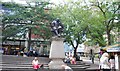
Statue of Sir Thomas Browne
Grade II listed. http://www.britishlistedbuildings.co.uk/en-229138-statue-of-sir-thomas-browne-norwich
Image: © N Chadwick
Taken: 30 Jun 2011
0.01 miles
4
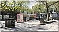
Hay Hill during the Coronavirus pandemic
Usually teeming with tourists and shoppers, with all pubs, restaurants and non-essential shops being closed, most people are adhering to the lockdown rules and stay at home. Consequently, the city's streets are devoid of people and vehicular traffic.
Image: © Evelyn Simak
Taken: 19 Apr 2020
0.01 miles
5
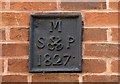
William Booth Street - parish boundary marker
The plate is affixed to the rear wall of McDonald's (formerly the George & Dragon public house) at Hay Hill > http://www.geograph.org.uk/photo/5863149. It marks the boundary of the parish of St Peter Mancroft (the crossed keys are Saint Peter's symbol) and dates from 1827.
See also my article: https://www.geograph.org.uk/article/Norwich-Boundary-Marker-Plates.
Image: © Evelyn Simak
Taken: 2 Aug 2018
0.01 miles
6
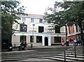
18 Hay Hill - McDonald's
The building housing McDonald's used to be the George & Dragon pub. It dates from the 19th century and is Grade 2 listed.
Image: © Evelyn Simak
Taken: 11 Jul 2018
0.01 miles
7
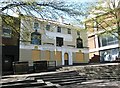
McDonald's at Hay Hill
Closed and boarded up during the Coronavirus pandemic.
Image: © Evelyn Simak
Taken: 19 Apr 2020
0.01 miles
8
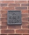
Old Boundary Marker by William Booth Street, Norwich
Parish Boundary Marker by the UC road, in parish of Norwich (Norwich District), William Booth Street, on side of McDonald's, on brick wall, 1st floor level, East side of road.
Inscription reads:-
M
S{crossed keys}P
1827
Surveyed
Milestone Society National ID: NO_NORSPM05pb
Image: © Milestone Society
Taken: Unknown
0.02 miles
9
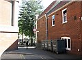
William Booth Street
William Booth Street is a very short street leading from Rampant Horse Street to Hay Hill. On the wall at right, which is the rear of McDonald's at Hay Hill > https://www.geograph.org.uk/photo/5839733, a parish boundary marker plate can be seen > https://www.geograph.org.uk/photo/5863154.
Image: © Evelyn Simak
Taken: 2 Aug 2018
0.02 miles