
IMAGES TAKEN NEAR TO
The Green, FAKENHAM, NR21 9PD
Introduction
This page details the photographs taken nearby to The Green, NR21 9PD by members of the Geograph project.
The Geograph project started in 2005 with the aim of publishing, organising and preserving representative images for every square kilometre of Great Britain, Ireland and the Isle of Man.

There are currently over 7.5m images from over14,400 individuals and you can help contribute to the project by visiting https://www.geograph.org.uk
Image Map
Images are licensed for reuse under creativecommons.org/licenses/by-sa/2.0
Notes
- Clicking on the map will re-center to the selected point.
- The higher the marker number, the further away the image location is from the centre of the postcode.
Image Listing (37 Images Found)
Images are licensed for reuse under creativecommons.org/licenses/by-sa/2.0
Image
Details
Distance
1
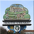
South Creake village sign (east face)
The sign is double sided, showing on the side facing the road, the church of St. Mary and a team of horses ploughing a field. On the reverse a battle is taking place between the locals and the invading Danes. In the background is the Iron Age hill fort south west of the village. The road down from the hill fort is called Bloodgate Hill and no doubt named because the road flowed red with the blood of the slain. https://www.geograph.org.uk/photo/4400435
https://www.geograph.org.uk/photo/6793882
Image: © Adrian S Pye
Taken: 31 Mar 2021
0.03 miles
2
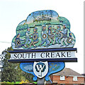
South Creake village sign (west face)
The sign is double sided, showing on the side facing the road, the church of St. Mary and a team of horses ploughing a field. On the reverse a battle is taking place between the locals and the invading Danes. In the background is the Iron Age hill fort south west of the village. The road down from the hill fort is called Bloodgate Hill and no doubt named because the road flowed red with the blood of the slain. https://www.geograph.org.uk/photo/4400435 https://www.geograph.org.uk/photo/6793884
Image: © Adrian S Pye
Taken: 31 Mar 2021
0.03 miles
3
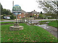
South Creake Village Sign, Footbridge and Ford
The village sign has a different image on the 2 sides; see Image for a view of the other side.
The footbridge and ford are on the River Burn at the edge of the village green.
The road in the background is the B1355, Burnham Market to Fakenham road.
Image: © G Laird
Taken: 26 Oct 2017
0.03 miles
4
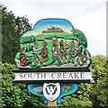
South Creake village sign
The sign is double sided, showing on the side facing the road, the church of St. Mary and a team of horses ploughing a field. On the reverse a battle is taking place between the locals and the invading Danes. In the background is the Iron Age hill fort south west of the village. The road down from the hill fort is called Bloodgate Hill and no doubt named because the road flowed red with the blood of the slain. https://www.geograph.org.uk/photo/5586417
Image: © Adrian S Pye
Taken: 2 Sep 2010
0.03 miles
5

South Creake village sign
The sign is double sided, showing on the side facing the road, the church of St. Mary and a team of horses ploughing a field. On the reverse a battle is taking place between the locals and the invading Danes. In the background is the Iron Age hill fort south west of the village. The road down from the hill fort is called Bloodgate Hill and no doubt named because the road flowed red with the blood of the slain.
https://www.geograph.org.uk/photo/6793882 https://www.geograph.org.uk/photo/6793884
Image: © Adrian S Pye
Taken: 2 Sep 2010
0.03 miles
6
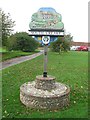
South Creake Village Sign
The village sign is located at the edge of the village green beside the River Burn.
Image: © G Laird
Taken: 26 Oct 2017
0.03 miles
7
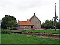
Flint and brick house
By the bridge over the River Burn. The village of South Creake is located on the B1355, five miles northwest of Fakenham and one mile south of the twin village of North Creake. The River Burn which merges with the North Sea at Holkham beach > http://www.geograph.org.uk/photo/941139 - http://www.geograph.org.uk/photo/941150 flows through the centre of the village > http://www.geograph.org.uk/photo/942536.
Image: © Evelyn Simak
Taken: 29 Aug 2008
0.03 miles
8
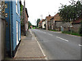
View southeast along Front Street (B1355)
See > http://www.geograph.org.uk/photo/942547 for a view in the opposite direction.
The village of South Creake is located on the B1355, five miles northwest of Fakenham and one mile south of the twin village of North Creake. The River Burn which merges with the North Sea at Holkham beach > http://www.geograph.org.uk/photo/941139 - http://www.geograph.org.uk/photo/941150 flows through the centre of the village > http://www.geograph.org.uk/photo/942536.
Image: © Evelyn Simak
Taken: 29 Aug 2008
0.03 miles
10
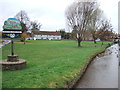
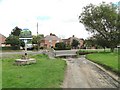
The Green in South Creake
Deserted, except from the ducks, on this wet and windy November day
Image: © Richard Humphrey
Taken: 20 Nov 2012
0.04 miles