IMAGES TAKEN NEAR TO
Smiths Lane, FAKENHAM, NR21 8LG
Introduction
This page details the photographs taken nearby to Smiths Lane, NR21 8LG by members of the Geograph project.
The Geograph project started in 2005 with the aim of publishing, organising and preserving representative images for every square kilometre of Great Britain, Ireland and the Isle of Man.

There are currently over 7.5m images from over14,400 individuals and you can help contribute to the project by visiting https://www.geograph.org.uk
Image Map
Images are licensed for reuse under creativecommons.org/licenses/by-sa/2.0
Notes
- Clicking on the map will re-center to the selected point.
- The higher the marker number, the further away the image location is from the centre of the postcode.
Image Listing (12 Images Found)
Images are licensed for reuse under creativecommons.org/licenses/by-sa/2.0
Image
Details
Distance
3
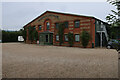
Marston & Langinger, Fakenham Industrial Estate
Image: © Hugh Venables
Taken: 17 Oct 2021
0.09 miles
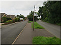
7
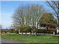
Norwich Road, Fakenham
At long last spring has arrived
Image: © Richard Humphrey
Taken: 21 Apr 2013
0.15 miles
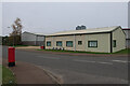
8
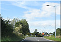
A1067 into Fakenham
Approaching the B&Q roundabout.
Image: © Pauline E
Taken: 17 Sep 2012
0.19 miles