
IMAGES TAKEN NEAR TO
Maltings Close, FAKENHAM, NR21 8HS
Introduction
This page details the photographs taken nearby to Maltings Close, NR21 8HS by members of the Geograph project.
The Geograph project started in 2005 with the aim of publishing, organising and preserving representative images for every square kilometre of Great Britain, Ireland and the Isle of Man.

There are currently over 7.5m images from over14,400 individuals and you can help contribute to the project by visiting https://www.geograph.org.uk
Image Map
Images are licensed for reuse under creativecommons.org/licenses/by-sa/2.0
Notes
- Clicking on the map will re-center to the selected point.
- The higher the marker number, the further away the image location is from the centre of the postcode.
Image Listing (25 Images Found)
Images are licensed for reuse under creativecommons.org/licenses/by-sa/2.0
Image
Details
Distance
1
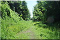
In the Cutting
A view of the large cutting through Fakenham coming to an end. Becoming housing before the Station site is reached Image The cutting now hosts a small footpath.
Image: © Ashley Dace
Taken: 3 Jun 2010
0.02 miles
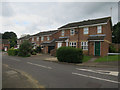
3
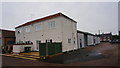
Former Drill Hall, Fakenham (5)
On Holt Road,this was originally the drill hall, built during the Boer War, for
5th Battalion, Norfolk Regiment (C Company)
6th (Cyclist) Battalion, Norfolk Regiment (E Company)
Norfolk Yeomanry (C Squadron)
The building was later the Regal Picture House. It has also been used as a dance hall. Now occupied by RJ Francis Motorcycles. There is a workshop for a monumental mason round the side, and this view shows the rear of the building, the oldest part,which is now residential.
Image: © Peter Barr
Taken: 15 Nov 2014
0.08 miles
4
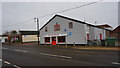
Former Drill Hall, Fakenham
On Holt Road,this was originally the drill hall, built during the Boer War, for
5th Battalion, Norfolk Regiment (C Company)
6th (Cyclist) Battalion, Norfolk Regiment (E Company)
Norfolk Yeomanry (C Squadron)
The building was later the Regal Picture House. It has also been used as a dance hall. Now occupied by RJ Francis Motorcycles. There is a workshop for a monumental mason round the side, and the rear of the building, the oldest part is now residential.
Image: © Peter Barr
Taken: 15 Nov 2014
0.10 miles
5
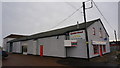
Former Drill Hall, Fakenham (2)
On Holt Road,this was originally the drill hall, built during the Boer War, for
5th Battalion, Norfolk Regiment (C Company)
6th (Cyclist) Battalion, Norfolk Regiment (E Company)
Norfolk Yeomanry (C Squadron)
The building was later the Regal Picture House. It has also been used as a dance hall. Now occupied by RJ Francis Motorcycles. There is a workshop for a monumental mason round the side, and the rear of the building, the oldest part, is now residential.
Image: © Peter Barr
Taken: 15 Nov 2014
0.10 miles
6
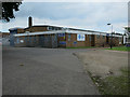
Aldiss distribution centre, Fakenham
Furniture and homeware store in Norwich and Fakenham.
Image: © Hugh Venables
Taken: 26 Jun 2016
0.11 miles
7
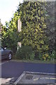
Former Level Crossing post at Fakenham East Station
See Image]
Image: © Ashley Dace
Taken: 3 Jun 2010
0.11 miles
8
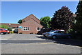
Site of Fakenham East Railway Station
This is the only station on the route (Wells to Wymondham) which has gone with out a trace (well almost). The station in 1969 can be seen here. A gate post from the crossing has been preserved but I think it has moved position from its old one. http://www.remembernorfolk.org/viewlarge.aspx?GI=23&MI=51000230317 The white post on the right is the level crossing post in the picture.
Image: © Ashley Dace
Taken: 3 Jun 2010
0.11 miles
9
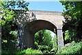
Old Three Arched Bridge in the Cutting
A view of the large bridge over a disused railway cutting. The Fakenham to Wells on Sea closed in 1964 and the cutting abandoned. Some has been filled in and built on.
Image: © Ashley Dace
Taken: 3 Jun 2010
0.11 miles
10
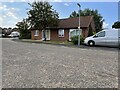
Fakenham East railway station (site), Norfolk
Opened in 1849 by the Eastern Counties Railway, later part of the Great Eastern Railway, on the line from Wymondham to Wells, this station closed in 1964. Goods trains carried on until around 1980 when the track was lifted.
View north west approximately along the single platform which had the track to the right of it. The station buildings would have been just behind the current bungalow, and beyond that, a level crossing for Norwich Road. As can be seen, the site has been redeveloped as a housing estate.
Image: © Nigel Thompson
Taken: 4 Aug 2021
0.12 miles