IMAGES TAKEN NEAR TO
Holt Road, FAKENHAM, NR21 8EG
Introduction
This page details the photographs taken nearby to Holt Road, NR21 8EG by members of the Geograph project.
The Geograph project started in 2005 with the aim of publishing, organising and preserving representative images for every square kilometre of Great Britain, Ireland and the Isle of Man.

There are currently over 7.5m images from over14,400 individuals and you can help contribute to the project by visiting https://www.geograph.org.uk
Image Map
Images are licensed for reuse under creativecommons.org/licenses/by-sa/2.0
Notes
- Clicking on the map will re-center to the selected point.
- The higher the marker number, the further away the image location is from the centre of the postcode.
Image Listing (25 Images Found)
Images are licensed for reuse under creativecommons.org/licenses/by-sa/2.0
Image
Details
Distance
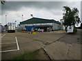
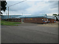
1
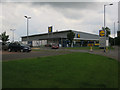
Linda McCartney Foods, Fakenham
Part of the Hain Daniels group.
Image: © Hugh Venables
Taken: 26 Jun 2016
0.02 miles
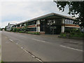
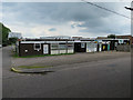
2
Hain Daniels Group, Fakenham
Food and drink factory.
Image: © Hugh Venables
Taken: 26 Jun 2016
0.04 miles
4
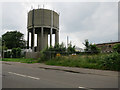
Water tower, Fakenham
With the usual set of mobile phone masts.
Image: © Hugh Venables
Taken: 26 Jun 2016
0.07 miles
5
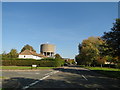
Fakenham water tower
From Holt Road near Waterfield Avenue
Image: © Adrian S Pye
Taken: 10 Oct 2018
0.07 miles
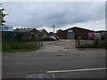
9
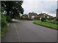
H.D.S., Fakenham
Harwood Domestic Services, repairs and sales of household electrical items.
Image: © Hugh Venables
Taken: 26 Jun 2016
0.14 miles