IMAGES TAKEN NEAR TO
Dereham Road, FAKENHAM, NR21 7NQ
Introduction
This page details the photographs taken nearby to Dereham Road, NR21 7NQ by members of the Geograph project.
The Geograph project started in 2005 with the aim of publishing, organising and preserving representative images for every square kilometre of Great Britain, Ireland and the Isle of Man.

There are currently over 7.5m images from over14,400 individuals and you can help contribute to the project by visiting https://www.geograph.org.uk
Image Map
Images are licensed for reuse under creativecommons.org/licenses/by-sa/2.0
Notes
- Clicking on the map will re-center to the selected point.
- The higher the marker number, the further away the image location is from the centre of the postcode.
Image Listing (8 Images Found)
Images are licensed for reuse under creativecommons.org/licenses/by-sa/2.0
Image
Details
Distance
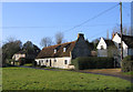
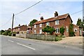
3
Colkirk, Norfolk
– view N of the rear of houses along the Dereham Road.
Image: © Rodney Burton
Taken: 15 Feb 2006
0.07 miles
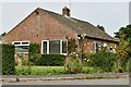
5
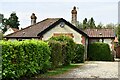
Colkirk: Bungalow, 3 Whissonsett Road
Image: © Michael Garlick
Taken: 8 Sep 2023
0.15 miles
6
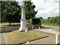
Colkirk War Memorial
The Memorial which stands predominantly in the village bears 16 names of men lost in WW1 and of one man lost in WW2.
Image: © Adrian S Pye
Taken: 9 Jul 2015
0.19 miles
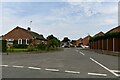
7
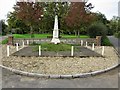
Colkirk War Memorial and Village Green
The war memorial is a tapering marble obelisk set on a grassy base at the south-east end of the village green at the fork of Church Road (left) and Market Hill (right).
Image: © G Laird
Taken: 26 Oct 2017
0.20 miles