IMAGES TAKEN NEAR TO
Swaffham Road, FAKENHAM, NR21 7DZ
Introduction
This page details the photographs taken nearby to Swaffham Road, NR21 7DZ by members of the Geograph project.
The Geograph project started in 2005 with the aim of publishing, organising and preserving representative images for every square kilometre of Great Britain, Ireland and the Isle of Man.

There are currently over 7.5m images from over14,400 individuals and you can help contribute to the project by visiting https://www.geograph.org.uk
Image Map
Images are licensed for reuse under creativecommons.org/licenses/by-sa/2.0
Notes
- Clicking on the map will re-center to the selected point.
- The higher the marker number, the further away the image location is from the centre of the postcode.
Image Listing (15 Images Found)
Images are licensed for reuse under creativecommons.org/licenses/by-sa/2.0
Image
Details
Distance
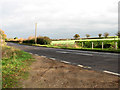
2
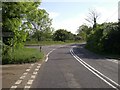
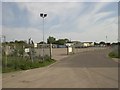
Junction A1065, Hempton
Light industrial estate and recycling centre off to the left along lane to Helhoughton
Image: © Nigel Jones
Taken: 22 May 2007
0.05 miles
3
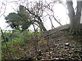
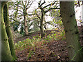
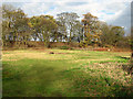
Trees on the edge of disused gravel pits, Hempton
Image: © Evelyn Simak
Taken: 29 Nov 2011
0.07 miles
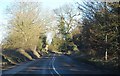
5
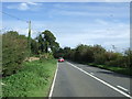
A1065 approaching Hempton
Looking north east.
Image: © JThomas
Taken: 30 Sep 2017
0.08 miles
9
Agricultural fertilizer distribution centre, Hempton
Image: © Nigel Jones
Taken: 22 May 2007
0.16 miles