IMAGES TAKEN NEAR TO
Fakenham Road, FAKENHAM, NR21 7AS
Introduction
This page details the photographs taken nearby to Fakenham Road, NR21 7AS by members of the Geograph project.
The Geograph project started in 2005 with the aim of publishing, organising and preserving representative images for every square kilometre of Great Britain, Ireland and the Isle of Man.

There are currently over 7.5m images from over14,400 individuals and you can help contribute to the project by visiting https://www.geograph.org.uk
Image Map
Images are licensed for reuse under creativecommons.org/licenses/by-sa/2.0
Notes
- Clicking on the map will re-center to the selected point.
- The higher the marker number, the further away the image location is from the centre of the postcode.
Image Listing (45 Images Found)
Images are licensed for reuse under creativecommons.org/licenses/by-sa/2.0
Image
Details
Distance
1
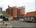
Crisp Maltings
According to the company's website http://www.crispmalt.info/ this is one of the largest and most efficient maltings in the UK. It dominates the village centre and, whilst this may not please everyone, it is good to see an apparently successful commercial venture with a direct link to the agricultural economy in this area.
Image: © Nigel Jones
Taken: 5 Jun 2007
0.03 miles
2
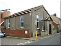
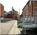
Memorial Hall, Great Ryburgh
Note the flooded road in the foreground, the result of a burst water main.
Image: © Jonathan Thacker
Taken: 6 Sep 2022
0.04 miles
3
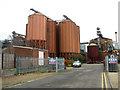
Silos at Crisp Maltings, Great Ryburgh
Image: © Evelyn Simak
Taken: 29 Nov 2011
0.04 miles
4
Flats and silos at Crisp Maltings, Great Ryburgh
Image: © Evelyn Simak
Taken: 29 Nov 2011
0.04 miles
6
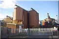
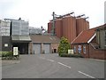
Crisp Maltings, Great Ryburgh
Seen here from the site of the former Ryburgh station, this sizeable plant produces 115,000 tonnes of finished malt annually. Although perhaps not very pretty, it is a valuable source of employment in a rural area. More details about the maltings are available here:http://www.crispmalt.info/greatry.html .
Image: © Stephen McKay
Taken: 29 Oct 2011
0.05 miles
8
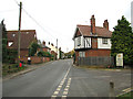
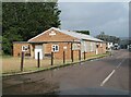
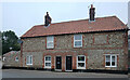
Cottages in Fakenham Road, Great Ryburgh
The cottage at left is the former Station House. The former railway crossing can be seen in the foreground. For more information go to: http://www.geograph.org.uk/photo/1895410.
Image: © Evelyn Simak
Taken: 29 Nov 2011
0.05 miles
9
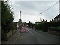
Road Closed at Great Ryburgh
Fakenham Road closed because of a burst water main. However no work seemed to be going on to repair the main and no vehicle took the slightest notice of the Road Closed sign.
Image: © Jonathan Thacker
Taken: 6 Sep 2022
0.05 miles