IMAGES TAKEN NEAR TO
Thursford Road, FAKENHAM, NR21 0JL
Introduction
This page details the photographs taken nearby to Thursford Road, NR21 0JL by members of the Geograph project.
The Geograph project started in 2005 with the aim of publishing, organising and preserving representative images for every square kilometre of Great Britain, Ireland and the Isle of Man.

There are currently over 7.5m images from over14,400 individuals and you can help contribute to the project by visiting https://www.geograph.org.uk
Image Map
Images are licensed for reuse under creativecommons.org/licenses/by-sa/2.0
Notes
- Clicking on the map will re-center to the selected point.
- The higher the marker number, the further away the image location is from the centre of the postcode.
Image Listing (36 Images Found)
Images are licensed for reuse under creativecommons.org/licenses/by-sa/2.0
Image
Details
Distance
1
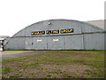
Blister hangar on Little Snoring Airfield
It is used by the McAully Flying Club which is based here. The hangar is not one of the original buildings of RAF Little Snoring.
Image: © Evelyn Simak
Taken: 18 Aug 2014
0.01 miles
2
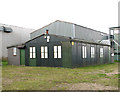
McAully Flying Club - the club house
This is an original airfield building which was relocated from Langham to Little Snoring. It once used to house RAF Langham's base chapel.
Image: © Evelyn Simak
Taken: 18 Aug 2014
0.01 miles
3
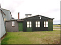
McAully Flying Club - the club house
This is an original airfield building which was relocated from Langham to Little Snoring. It once used to house RAF Langham's base chapel.
Image: © Evelyn Simak
Taken: 18 Aug 2014
0.01 miles
4
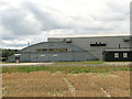
Hangars on Little Snoring Airfield
The blister hangar is used by the McAully Flying Club. The large T2 aircraft hangar > http://www.geograph.org.uk/photo/4126826 seen behind it is an original building which was put up at this location during WW2 when RAF Little Snoring was an active airfield. It is currently used for storage. The small building seen at right is the club house > http://www.geograph.org.uk/photo/4126836. It was relocated from Langham where it housed the station's chapel when RAF Langham was an active airfield, also during WW2.
Image: © Evelyn Simak
Taken: 18 Aug 2014
0.01 miles
5
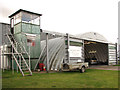
The Light Aircraft Company (TLAC)
The company is based on Little Snoring airfield and produces the classic two-seater Sherwood Ranger biplane in both Microlight and Cat A format. Their modern control tower can be seen at left.
Image: © Evelyn Simak
Taken: 18 Aug 2014
0.03 miles
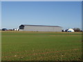
6
T2 aircraft hangar at Little Snoring Airfield
The hangar, which has since been re-clad, is one of two original T2 aircraft hangars which can still be seen at the airfield. It is currently used for storage.
Image: © Evelyn Simak
Taken: 18 Aug 2014
0.03 miles
7
Old aircraft hangar
This is Little Snoring Airfield, used by Mosquito squadrons in World War Two. The gates were closed just at the end of 1945 and since then it has been used for private and club flying, including microlights. The old hangars are still there, like this one, and they are used for storage facilities. The airfield itself, apart from small sections of runway, is in agricultural use.
Image: © David Williams
Taken: 14 Jan 2007
0.04 miles
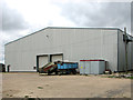
8
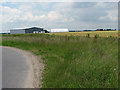
Buildings, Little Snoring Airfield
Former RAF, now a private airfield.
Image: © JThomas
Taken: 4 Oct 2020
0.04 miles
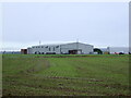
9
Hangars at Little Snoring airfield
The derelict control tower (in adjacent grid square) can be seen in the distance, to the right of the hangars. See also > http://www.geograph.org.uk/photo/849738.
Image: © Evelyn Simak
Taken: 17 Jun 2008
0.05 miles
10
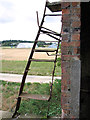
View from the old Watch office
View across the adjoining cropfields towards the location of the former Technical site, today occupied mainly by modern buildings belonging to the McAully Flying Club and The Light Aircraft Company. The steps seen in the foreground once used to lead up to the roof of the Watch office. For a full view of the Watch office see > http://www.geograph.org.uk/photo/4126878.
Image: © Evelyn Simak
Taken: 18 Aug 2014
0.05 miles