
IMAGES TAKEN NEAR TO
Mill Road, FAKENHAM, NR21 0ED
Introduction
This page details the photographs taken nearby to Mill Road, NR21 0ED by members of the Geograph project.
The Geograph project started in 2005 with the aim of publishing, organising and preserving representative images for every square kilometre of Great Britain, Ireland and the Isle of Man.

There are currently over 7.5m images from over14,400 individuals and you can help contribute to the project by visiting https://www.geograph.org.uk
Image Map
Images are licensed for reuse under creativecommons.org/licenses/by-sa/2.0
Notes
- Clicking on the map will re-center to the selected point.
- The higher the marker number, the further away the image location is from the centre of the postcode.
Image Listing (22 Images Found)
Images are licensed for reuse under creativecommons.org/licenses/by-sa/2.0
Image
Details
Distance
1

Lodges and gate, Sennowe Hall and Park
Sennowe House was originally a Georgian house built in 1774 for Edmond Wodhouse MP. It was subsequently owned by the Morse-Boycott family (who had it re-built by Decimus Burton), Bernard Le Neve Foster (a lighting engineer), and then Thomas Cook, he of the eponymous travel agency. It is still owned by a Thomas Cook, great-great-grandson of the Thomas Cook. My information is mainly drawn from an Eastern Daily Press article of November 2003.
Image: © Nigel Jones
Taken: 15 Aug 2007
0.00 miles
2

Lodges and gates near Gateley
The entrance to Sennowe Hall from the minor road to Gateley is grander than that on the main Norwich Road (Image]). Here, the lodges have cupola-topped towers. By George Skipper, 1905-08. Grade II listed.
Image: © Stephen Richards
Taken: 18 Jun 2013
0.01 miles
3

Ryburgh Lodges at the gateway to Sennowe Park
Image: © JThomas
Taken: 4 Oct 2020
0.01 miles
4

Lodges at the gates of Sennowe Park
A similar view to Nigel Jones's, but with more dramatic lighting. Just a brief description of Sennowe Hall appears in Pevsner. See the entry for the village of Guist, in the North-East Norfolk and Norwich volume of 'The Buildings of England'.
Image: © Stefan Czapski
Taken: 11 Jul 2008
0.03 miles
5

Gate piers near Great Ryburgh
Described by the listing as "pillars flanking road and marking edge of Sennowe Park. 1905- 8 by G. Skipper". Grade II listed.
Image: © Stephen Richards
Taken: 18 Jun 2013
0.05 miles
6

Tin barn and Owl box
An old tin barn with a box for owls.
Image: © Ashley Dace
Taken: 3 Jun 2010
0.05 miles
7

National Cycle Route 1 towards Great Ryburgh
Beside Elgar's Plantation.
Image: © JThomas
Taken: 4 Oct 2020
0.07 miles
8
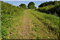
Track to Great Ryburgh
A view of the trackbed, complete of ballast towards Great Ryburgh.
The Trackbed north of County School to Fakenham Gas Museum (including M&GN trackbed) is in private hands but protected from development. The major obstacle being Great Ryburgh Maltings, being built on the trackbed.
Image: © Ashley Dace
Taken: 3 Jun 2010
0.08 miles
9

Trackbed to Great Ryburgh
A view of the dismantled railway north to Great Ryburgh.
Image: © Ashley Dace
Taken: 3 Jun 2010
0.09 miles
10
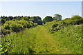
Trackbed to County School
A view looking towards bridge 1711 on the dismantled Wymondham to Wells Branch.
The Trackbed north of County School to Fakenham Gas Museum (including M&GN trackbed) is in private hands but protected from development. The major obstacle being Great Ryburgh Maltings, being built on the trackbed.
Image: © Ashley Dace
Taken: 3 Jun 2010
0.12 miles