IMAGES TAKEN NEAR TO
Fakenham Road, FAKENHAM, NR21 0BE
Introduction
This page details the photographs taken nearby to Fakenham Road, NR21 0BE by members of the Geograph project.
The Geograph project started in 2005 with the aim of publishing, organising and preserving representative images for every square kilometre of Great Britain, Ireland and the Isle of Man.

There are currently over 7.5m images from over14,400 individuals and you can help contribute to the project by visiting https://www.geograph.org.uk
Image Map
Images are licensed for reuse under creativecommons.org/licenses/by-sa/2.0
Notes
- Clicking on the map will re-center to the selected point.
- The higher the marker number, the further away the image location is from the centre of the postcode.
Image Listing (19 Images Found)
Images are licensed for reuse under creativecommons.org/licenses/by-sa/2.0
Image
Details
Distance
5
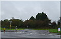
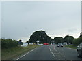
B1354, Thursford
At the junction with the A148.
Image: © JThomas
Taken: 4 Oct 2020
0.09 miles
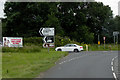
6
Near Station Farm
By the cross road near Station Farm.
Image: © Malcolm Neal
Taken: 5 Aug 2019
0.11 miles
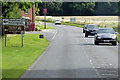
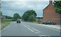
7
The Crawfish Public House
The Crawfish Public House is on the A148 Kings Lynn to Cromer Road
Image: © Mark Hobbs
Taken: 9 Mar 2009
0.12 miles
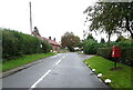
8
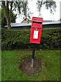
Elizabeth II postbox on Station Road, Thursford
Postbox No. NR21 2107.
See Image] for context.
Image: © JThomas
Taken: 4 Oct 2020
0.12 miles
9
Station Road, Thursford
Showing position of Postbox No. NR21 2107.
See Image] for postbox.
Image: © JThomas
Taken: 4 Oct 2020
0.12 miles
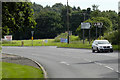
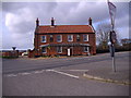
10
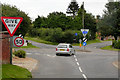
Joining the A148 at the Crawfish Inn
Junction between Thursford Road and the A148 at the side of the Crawfish Inn.
Image: © David Dixon
Taken: 3 Aug 2015
0.13 miles