
IMAGES TAKEN NEAR TO
Rectory Road, DEREHAM, NR20 5TF
Introduction
This page details the photographs taken nearby to Rectory Road, NR20 5TF by members of the Geograph project.
The Geograph project started in 2005 with the aim of publishing, organising and preserving representative images for every square kilometre of Great Britain, Ireland and the Isle of Man.

There are currently over 7.5m images from over14,400 individuals and you can help contribute to the project by visiting https://www.geograph.org.uk
Image Map
Images are licensed for reuse under creativecommons.org/licenses/by-sa/2.0
Notes
- Clicking on the map will re-center to the selected point.
- The higher the marker number, the further away the image location is from the centre of the postcode.
Image Listing (5 Images Found)
Images are licensed for reuse under creativecommons.org/licenses/by-sa/2.0
Image
Details
Distance


3
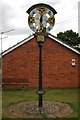
Village sign
The village sign at Whissonsett, Norfolk. A plaque on a post in front of the sign reads... Whissonsett Village Sign.
designed by Mr I.Newton, unveiled June 29th 1985 by Lt.Col. J.Seagrim.
Lt.Col. Derek Seagrim V.C. and Major Hugh Seagrim G.C. M.B.E. D.S.O. are shown with the Saxon Cross, an apple, millstocks and the spring well.
Image: © Craig Tuck
Taken: 12 Jul 2009
0.24 miles
4
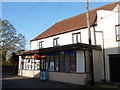
Whissonsett: the post office/stores
Whissonsett's village store and post office is situated in the centre of the village and has a traditional, unmodernised feel both outside and in.
Image: © Chris Downer
Taken: 28 Nov 2011
0.24 miles
5
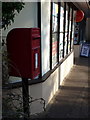
Whissonsett: postbox № NR20 2065
A closer look at the postbox, a standard Elizabeth II-reign lamp box on a metal pole, which stands outside Image It is emptied finally at 4:45pm on weekdays and at 10:40am on Saturdays.
Image: © Chris Downer
Taken: 28 Nov 2011
0.24 miles