
IMAGES TAKEN NEAR TO
North Elmham, DEREHAM, NR20 5LB
Introduction
This page details the photographs taken nearby to NR20 5LB by members of the Geograph project.
The Geograph project started in 2005 with the aim of publishing, organising and preserving representative images for every square kilometre of Great Britain, Ireland and the Isle of Man.

There are currently over 7.5m images from over14,400 individuals and you can help contribute to the project by visiting https://www.geograph.org.uk
Image Map
Images are licensed for reuse under creativecommons.org/licenses/by-sa/2.0
Notes
- Clicking on the map will re-center to the selected point.
- The higher the marker number, the further away the image location is from the centre of the postcode.
Image Listing (85 Images Found)
Images are licensed for reuse under creativecommons.org/licenses/by-sa/2.0
Image
Details
Distance
1

Grange Farm
A look over to grange farm .
Image: © Ashley Dace
Taken: 3 Jun 2010
0.02 miles
2

The End of the Line
Currently where the track at County School ends and the trackbed to North Elmham begins. The gap between is only a mile or so but services can't run due to a small volunteer force doing the massive task of restoring it. There are thousands of sleepers between here and Dereham that require replacement.
Image: © Ashley Dace
Taken: 2 Apr 2010
0.12 miles
3

Old Crossing on the Trackbed
An old farmers crossing, converted to a pedestrian gate. Part of the old Fakenham to Dereham line.
The trackbed here is private, I was on a supervised walking event.
Image: © Ashley Dace
Taken: 2 Apr 2010
0.12 miles

5

Path at County School
A path runs along side the railway for a short distance, neighbouring with a small drainage ditch.
Image: © Ashley Dace
Taken: 2 Apr 2010
0.13 miles
6

Line to North Elmham
A view of the line across the Wensum Valley. This track runs for a short distance before becoming trackbed to North Elmham. I saw the second barn owl of the day here, hunting in the distance. Possibly this individual Image]
Image: © Ashley Dace
Taken: 3 Jun 2010
0.13 miles
7

The Line Looking Towards County School
The old bridge that carried the single tracked Wymondham to Wells branch, this is just south of County School station. Some track was laid by the first preservation society, this is as far as it got. The trackbed from this point is private, I was on a supervised walking event.
Image: © Ashley Dace
Taken: 2 Apr 2010
0.13 miles
8
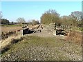
Railway trackbed near County School station
The trackbed crosses a drainage dyke on a little bridge, as it approaches County School station.
Image: © Paul Shreeve
Taken: 11 Feb 2008
0.13 miles
9

Concrete Bridge of the Old Railway Line
The old bridge (1707) that carried the single tracked Wymondham to Wells branch, this is just south of County School station http://www.geograph.org.uk/photo/1783990.
The trackbed continues, trackless to North Elmham.
Image: © Ashley Dace
Taken: 2 Apr 2010
0.14 miles
