
IMAGES TAKEN NEAR TO
Worthing, DEREHAM, NR20 5HP
Introduction
This page details the photographs taken nearby to NR20 5HP by members of the Geograph project.
The Geograph project started in 2005 with the aim of publishing, organising and preserving representative images for every square kilometre of Great Britain, Ireland and the Isle of Man.

There are currently over 7.5m images from over14,400 individuals and you can help contribute to the project by visiting https://www.geograph.org.uk
Image Map
Images are licensed for reuse under creativecommons.org/licenses/by-sa/2.0
Notes
- Clicking on the map will re-center to the selected point.
- The higher the marker number, the further away the image location is from the centre of the postcode.
Image Listing (13 Images Found)
Images are licensed for reuse under creativecommons.org/licenses/by-sa/2.0
Image
Details
Distance
1

Mill & river
Mill on the River Wensum at Worthing, Norfolk
Image: © Craig Tuck
Taken: 6 Mar 2009
0.00 miles
2

Worthing Mill
Although having stopped commercial operation in 1928, Worthing Mill still stands beside the River Blackwater.
Image: © Adrian Hodge
Taken: Unknown
0.04 miles
3

Opening the sluice
Worthing Mill, seen in the background, stands on the River Blackwater, a tributary of the River Wensum. Although the mill ceased commercial operation in 1928, the sluices, which control the water level above the mill are still used to regulate river flow.
Image: © Adrian Hodge
Taken: 19 Nov 2006
0.06 miles
4
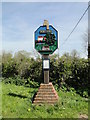
Worthing's new village sign
The new sign, erected in 2015 is moulded in fibreglass from the original wooden sign. Below the sign is an explanation of the features depicted.
Surmounting the sign is the 1800 year old Roman helmet found in the River Wensum; now in Norwich Museum. Worthing Mill and Mill House are illustrated and although the present mill only dates back 150 years, there has been a mill on the site since at least 1100.
Worthing Bridge over the River Blackwater and Horse Chestnut Tree also feature. Although the tree was felled in 2005 due to being in an advanced state of decay. The church is also featured with its stump of a tower. The sign says it's worth a visit, but it's always locked so I say don't bother. There is no welcome in a locked church. Finally the sign features highland cattle and sheep, illustrating the village's agricultural heritage.
Close up https://www.geograph.org.uk/photo/6797365
Compare with the old sign http://www.geograph.org.uk/photo/1219122
Image: © Adrian S Pye
Taken: 5 May 2016
0.08 miles
5
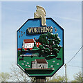
Worthing and Hoe village sign
The new sign, erected in 2015 is moulded in fibreglass from the original wooden sign. Below the sign is an explanation of the features depicted.
Surmounting the sign is the 1800 year old Roman helmet found in the River Wensum; now in Norwich Museum. Worthing Mill and Mill House are illustrated and although the present mill only dates back 150 years, there has been a mill on the site since at least 1100.
Worthing Bridge over the River Blackwater and Horse Chestnut Tree also feature. Although the tree was felled in 2005 due to being in an advanced state of decay. The church is also featured with its stump of a tower. The sign says it's worth a visit, but it's always locked so I say don't bother. There is no welcome in a locked church. Finally the sign features highland cattle and sheep, illustrating the village's agricultural heritage. https://www.geograph.org.uk/photo/4937274
Image: © Adrian S Pye
Taken: 5 May 2016
0.08 miles
6

Village Sign
Village sign at Worthing, Norfolk
Image: © Craig Tuck
Taken: 6 Mar 2009
0.08 miles
7

Bend in the road at the Worthing Village Sign
The previous old rotten wooden sign was used as a template for the mould for this new sign which was cast in fibre glass. It was erected in 2015.
Image: © G Laird
Taken: 25 Oct 2017
0.08 miles
8

Worthing Village Sign
The previous old rotten wooden sign was used as a template for the mould for this new sign which was cast in fibre glass. It was erected in 2015.
Image: © G Laird
Taken: 25 Oct 2017
0.09 miles

10

Railway Arms, North Elmham
http://www.geograph.org.uk/photo/5978639
Image: © Ian S
Taken: 9 Nov 2018
0.18 miles