IMAGES TAKEN NEAR TO
Church Road, DEREHAM, NR20 5DT
Introduction
This page details the photographs taken nearby to Church Road, NR20 5DT by members of the Geograph project.
The Geograph project started in 2005 with the aim of publishing, organising and preserving representative images for every square kilometre of Great Britain, Ireland and the Isle of Man.

There are currently over 7.5m images from over14,400 individuals and you can help contribute to the project by visiting https://www.geograph.org.uk
Image Map
Images are licensed for reuse under creativecommons.org/licenses/by-sa/2.0
Notes
- Clicking on the map will re-center to the selected point.
- The higher the marker number, the further away the image location is from the centre of the postcode.
Image Listing (40 Images Found)
Images are licensed for reuse under creativecommons.org/licenses/by-sa/2.0
Image
Details
Distance
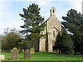
2
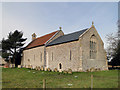
Lane past St Edmund's church in Horningtoft
For a view of the church see > http://www.geograph.org.uk/photo/1879071.
Image: © Evelyn Simak
Taken: 22 May 2010
0.07 miles
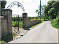
4
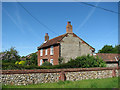
Flint and brick cottage in Horningtoft
Image: © Evelyn Simak
Taken: 22 May 2010
0.08 miles
5
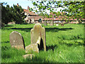
St Edmund's church in Horningtoft - churchyard
For a view of the church see > http://www.geograph.org.uk/photo/1879071.
Image: © Evelyn Simak
Taken: 22 May 2010
0.08 miles
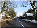
6
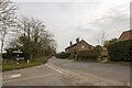
Church Road
Junction of Church Road and Brisley Road
Image: © P Gaskell
Taken: Unknown
0.09 miles
7
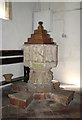
St Edmund's church in Horningtoft - C15 font
St Edmund's church > http://www.geograph.org.uk/photo/1879071 lost its tower - replaced by a bell cote in Victorian times - in the late 1700s. The building dates mainly from the 13th century, the simplicity of its interior being accented by altar frontal panels, reading desk > http://www.geograph.org.uk/photo/1879094 and rood screen > http://www.geograph.org.uk/photo/1879084 as well as wineglass pulpit > http://www.geograph.org.uk/photo/1879089 - all of which decorated with matching modern paintwork adornments. The octagonal font with carved lions on its stem is original and dates from the 15th century.
Image: © Evelyn Simak
Taken: 22 May 2010
0.09 miles
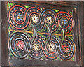
8
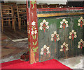
St Edmund's church in Horningtoft - rood screen (panels)
St Edmund's church > http://www.geograph.org.uk/photo/1879071 lost its tower - replaced by a bell cote in Victorian times - in the late 1700s. The building dates mainly from the 13th century, the simplicity of its interior being accented by altar frontal panels, reading desk > http://www.geograph.org.uk/photo/1879094 and rood screen > http://www.geograph.org.uk/photo/1879084 as well as wineglass pulpit > http://www.geograph.org.uk/photo/1879089 - all of which decorated with matching modern paintwork adornments. The octagonal font > http://www.geograph.org.uk/photo/1879104 with carved lions on its stem is original and dates from the 15th century.
Image: © Evelyn Simak
Taken: 22 May 2010
0.09 miles
10
St Edmund's church in Horningtoft - the pulpit (detail)
St Edmund's church > http://www.geograph.org.uk/photo/1879071 lost its tower - replaced by a bell cote in Victorian times - in the late 1700s. The building dates mainly from the 13th century, the simplicity of its interior being accented by altar frontal panels, reading desk > http://www.geograph.org.uk/photo/1879094 and rood screen > http://www.geograph.org.uk/photo/1879084 as well as wineglass pulpit > http://www.geograph.org.uk/photo/1879089 - all of which decorated with matching modern paintwork adornments. The octagonal font > http://www.geograph.org.uk/photo/1879104 with carved lions on its stem is original and dates from the 15th century.
Image: © Evelyn Simak
Taken: 22 May 2010
0.10 miles