IMAGES TAKEN NEAR TO
Moffett Road, DEREHAM, NR20 4FQ
Introduction
This page details the photographs taken nearby to Moffett Road, NR20 4FQ by members of the Geograph project.
The Geograph project started in 2005 with the aim of publishing, organising and preserving representative images for every square kilometre of Great Britain, Ireland and the Isle of Man.

There are currently over 7.5m images from over14,400 individuals and you can help contribute to the project by visiting https://www.geograph.org.uk
Image Map
Images are licensed for reuse under creativecommons.org/licenses/by-sa/2.0
Notes
- Clicking on the map will re-center to the selected point.
- The higher the marker number, the further away the image location is from the centre of the postcode.
Image Listing (75 Images Found)
Images are licensed for reuse under creativecommons.org/licenses/by-sa/2.0
Image
Details
Distance
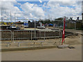
1
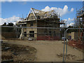
House under construction, Swanton Morley
Image: © Hugh Venables
Taken: 17 Apr 2016
0.01 miles
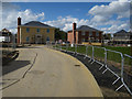
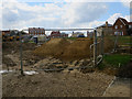
4
New housing development, Swanton Morley
Called Meadow View for the purposes of the initial marketing and sales.
Image: © Hugh Venables
Taken: 17 Apr 2016
0.04 miles
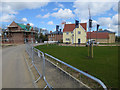
5
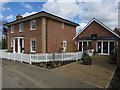
Meadow View marketing suite
New housing development in Swanton Morley.
Image: © Hugh Venables
Taken: 17 Apr 2016
0.04 miles
8
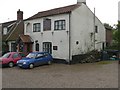
The Paper Makers
A Public House in Swanton Morley.
Image: © Roger Gilbertson
Taken: 5 Nov 2006
0.10 miles
9
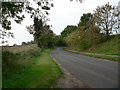
The Road To Robertson Barracks
From Swanton Morley.
Image: © Roger Gilbertson
Taken: 5 Nov 2006
0.10 miles
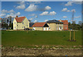
10
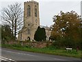
The Parish Church of All Saints
As seen from Mill Street, Swanton Morley.
Image: © Roger Gilbertson
Taken: 5 Nov 2006
0.10 miles