
IMAGES TAKEN NEAR TO
Bath Avenue, DEREHAM, NR20 3AP
Introduction
This page details the photographs taken nearby to Bath Avenue, NR20 3AP by members of the Geograph project.
The Geograph project started in 2005 with the aim of publishing, organising and preserving representative images for every square kilometre of Great Britain, Ireland and the Isle of Man.

There are currently over 7.5m images from over14,400 individuals and you can help contribute to the project by visiting https://www.geograph.org.uk
Image Map
Images are licensed for reuse under creativecommons.org/licenses/by-sa/2.0
Notes
- Clicking on the map will re-center to the selected point.
- The higher the marker number, the further away the image location is from the centre of the postcode.
Image Listing (111 Images Found)
Images are licensed for reuse under creativecommons.org/licenses/by-sa/2.0
Image
Details
Distance
2
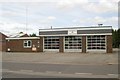
Dereham fire station
Dereham fire station, 43 Norwich Road, Dereham, Norfolk
Image: © Kevin Hale
Taken: 6 Jun 2009
0.05 miles
3
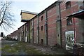
Crisps Maltings Dereham
A grade two listed building unfortunately on the buildings at risk register. However another maltings down the road is being restored so hopefully this one is next.
Image: © Ashley Dace
Taken: 19 Mar 2010
0.14 miles
4
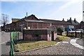
Pill Box and Crisps Maltings
A grade two listed building unfortunately on the buildings at risk register. However another maltings down the road is being restored so hopefully this one is next. The pillbox can be seen was built during the war to guard the goods yard.
Image: © Ashley Dace
Taken: 19 Mar 2010
0.14 miles
5
Crisps Maltings Dereham
A grade two listed building unfortunately on the buildings at risk register. However another maltings down the road is being restored so hopefully this one is next. The pillbox can be seen was built during the war to guard the goods yard.
Image: © Ashley Dace
Taken: 19 Mar 2010
0.14 miles
6
Former Maltings
This former maltings is now lying empty and derelict. The building dates from 1870 and is Grade II listed. Nearby another malting has been converted to apartments, so perhaps the same will happen here in due course.
Image: © mike smith
Taken: 8 Apr 2012
0.16 miles
7
Dereham Maltings and Dereham station goods yard
The listed Dereham Maltings with MNR liveried goods van in Dereham goods yard on the Mid Norfolk Railway.
Image: © Ashley Dace
Taken: 9 Aug 2008
0.17 miles
8

Dereham goods yard
The maltings are in the background. The object is a fuel point for the 'mechanical horses' these were early lorries that delivered items all around the town.
Image: © Ashley Dace
Taken: 15 Mar 2009
0.17 miles
9
Dereham goods yard and stables
The building on the right is the goods shed, the other building is the former stables. This is the last known Great Eastern railway stables left. It is hoped in the future to restore this with a lottery grant, giving the sight of horses shunting again.
Image: © Ashley Dace
Taken: 15 Mar 2009
0.17 miles
10

The Mid Norfolk railway, Dereham yard
The goods yard at Dereham station, the goods wagon in the background. The maltings (grade 2 listed) stand proud. Hopefully the maltings will be converted into flats like the one down the road which look brilliant.
Image: © Ashley Dace
Taken: 15 Mar 2009
0.17 miles