IMAGES TAKEN NEAR TO
Wendling Road, DEREHAM, NR19 2RE
Introduction
This page details the photographs taken nearby to Wendling Road, NR19 2RE by members of the Geograph project.
The Geograph project started in 2005 with the aim of publishing, organising and preserving representative images for every square kilometre of Great Britain, Ireland and the Isle of Man.

There are currently over 7.5m images from over14,400 individuals and you can help contribute to the project by visiting https://www.geograph.org.uk
Image Map
Images are licensed for reuse under creativecommons.org/licenses/by-sa/2.0
Notes
- Clicking on the map will re-center to the selected point.
- The higher the marker number, the further away the image location is from the centre of the postcode.
Image Listing (5 Images Found)
Images are licensed for reuse under creativecommons.org/licenses/by-sa/2.0
Image
Details
Distance
1
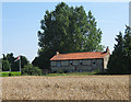
House on the edge of Hall Green
It is particularly difficult to photograph most houses in Hall Green as they hide behind especially high hedges or fences. This one, facing the road south to Wendling was an exception. However, the flying of the St George flag was typical of quite a few houses in the area.
Image: © Zorba the Geek
Taken: 11 Aug 2007
0.13 miles
3
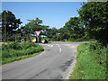
Wendling Road at Hall Green meets a larger road
Confusingly the major road is the road to Wendling (left) and Stanfield (right). The tractor and long trailer is probably on its way to collect a load of bales, this being the peak harvest period.
Image: © Zorba the Geek
Taken: 11 Aug 2007
0.19 miles
4
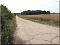
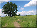
View along the eastern perimeter track
Much reduced in width, it is now a private farm road.
Image: © Evelyn Simak
Taken: 31 Jul 2014
0.23 miles