IMAGES TAKEN NEAR TO
Dereham Low Road, DEREHAM, NR19 2RA

Introduction

This page details the photographs taken nearby to Dereham Low Road, NR19 2RA by members of the Geograph project.

The Geograph project started in 2005 with the aim of publishing, organising and preserving representative images for every square kilometre of Great Britain, Ireland and the Isle of Man.

There are currently over 7.5m images from over14,400 individuals and you can help contribute to the project by visiting https://www.geograph.org.uk

Image Map


Images are licensed for reuse under creativecommons.org/licenses/by-sa/2.0
Notes
  • Clicking on the map will re-center to the selected point.
  • The higher the marker number, the further away the image location is from the centre of the postcode.

Image Listing (15 Images Found)

Images are licensed for reuse under creativecommons.org/licenses/by-sa/2.0
Image
Details
Distance
1
Longham: Small pond
Image: © Michael Garlick Taken: 5 Apr 2024
0.06 miles
2
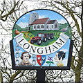
Longham village sign
The parish church of St Andrew features in the upper half of the sign with a tractor and trailer representing the agricultural community. A cock pheasant and English partridge are accompanied by some sprigs of lavender. Below the name are two of the villages notable residents. Victorian photographer Robert Howlett and his contemporary botanical painter Sarah Ann Drake are both featured. The chains represent the launching of Isambard Kingdom Brunel’s SS Great Eastern. Which Robert Howlett photographed. The flower is there because Sarah Ann Drake was instrumental in saving Kew Gardens by petitioning government. Some of her paintings can still be seen there. She is buried in the village graveyard. The coat of arms are those of Thomas Coke of Holkham Hall. https://www.geograph.org.uk/photo/6796594
Image: © Adrian S Pye Taken: 3 Apr 2021
0.12 miles
3
Longham village sign
The parish church of St Andrew features in the upper half of the sign with a tractor and trailer representing the agricultural community. A cock pheasant and English partridge are accompanied by some sprigs of lavender. Below the name are two of the villages notable residents. Victorian photographer Robert Howlett and his contemporary botanical painter Sarah Ann Drake are both featured. The chains represent the launching of Isambard Kingdom Brunel’s SS Great Eastern. Which Robert Howlett photographed. The flower is there because Sarah Ann Drake was instrumental in saving Kew Gardens by petitioning government. Some of her paintings can still be seen there. She is buried in the village graveyard. The coat of arms are those of Thomas Coke of Holkham Hall. https://www.geograph.org.uk/photo/6796592
Image: © Adrian S Pye Taken: 3 Apr 2021
0.12 miles
4
Postbox and information board in Chapel Road
Image: © Evelyn Simak Taken: 10 Jun 2014
0.13 miles
5
View along Chapel Road
The K6 phone kiosk seen at right is still functional. It stands beside the former Post Office > http://www.geograph.org.uk/photo/4021483 which closed a couple of years ago.
Image: © Evelyn Simak Taken: 10 Jun 2014
0.13 miles
6
Bungalow in Chapel Road
Image: © Evelyn Simak Taken: 10 Jun 2014
0.14 miles
7
Houses in Chapel Road
Until about two years ago, the house at left was the Post Office. The village shop was also once housed here; it closed several years before the Post Office was closed.
Image: © Evelyn Simak Taken: 10 Jun 2014
0.14 miles
8
Former Post Office and village shop
Until two years ago, the house seen at left was the Post Office. It also once housed the village shop, which was closed several years before the Post Office was also closed. For a view from when the PO was still open see > http://www.geograph.org.uk/photo/522884.
Image: © Evelyn Simak Taken: 10 Jun 2014
0.14 miles
9
K6 telephone kiosk in Chapel Road
This phone box is still functional. It stands beside the former Post Office > http://www.geograph.org.uk/photo/4021483 which closed a couple of years ago.
Image: © Evelyn Simak Taken: 10 Jun 2014
0.14 miles
10
The White Horse at Longham
This pub at the crossroads is in the next square east according to Explorer.
Image: © Zorba the Geek Taken: 11 Aug 2007
0.15 miles