IMAGES TAKEN NEAR TO
Abbey Close, DEREHAM, NR19 2LR
Introduction
This page details the photographs taken nearby to Abbey Close, NR19 2LR by members of the Geograph project.
The Geograph project started in 2005 with the aim of publishing, organising and preserving representative images for every square kilometre of Great Britain, Ireland and the Isle of Man.

There are currently over 7.5m images from over14,400 individuals and you can help contribute to the project by visiting https://www.geograph.org.uk
Image Map
Images are licensed for reuse under creativecommons.org/licenses/by-sa/2.0
Notes
- Clicking on the map will re-center to the selected point.
- The higher the marker number, the further away the image location is from the centre of the postcode.
Image Listing (8 Images Found)
Images are licensed for reuse under creativecommons.org/licenses/by-sa/2.0
Image
Details
Distance
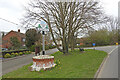
1
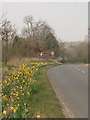
Roadside daffodils
Daffodils on the verge by the road into Wendling
Image: © Richard Mudhar
Taken: 30 Mar 2007
0.10 miles
2
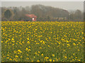
Early rapeseed
Field of rapeseed early in the season. Looks quite pleasant before it has all gone that virulently greeny-yellow colour.
Image: © Richard Mudhar
Taken: 30 Mar 2007
0.11 miles
3
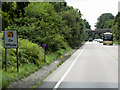
Emergency Telephone Sign on the Westbound A47 near to Wendling
Image: © David Dixon
Taken: 7 Aug 2015
0.21 miles
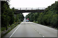
4
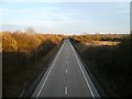
A47
The A47 heading towards Dereham, Norfolk. Taken from the road bridge at Wendling, Norfolk
Image: © Craig Tuck
Taken: 21 Feb 2009
0.23 miles
5
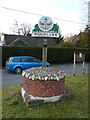
Village Sign
Village sign at Wendling, Norfolk
Image: © Craig Tuck
Taken: 21 Feb 2009
0.24 miles
6
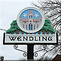
Wendling village sign
Wendling sign depicts an abbey founded in about 1256 and belonging to the Premonstratensian Order of Canons or white canons. The abbey lasted until 1536. There are no visible remains. The clouds in the sky are just as they appear on the old seal. The trees represent Honeypot Wood and because a few buildings from RAF Wendling remain within its boundary the airfield is also not forgotten. The Wendling Beck, which is pictured in blue behind the trees, meanders its way through the parish. https://www.geograph.org.uk/photo/6796710
Image: © Adrian S Pye
Taken: 3 Apr 2021
0.24 miles
7
Wendling village sign
Wendling sign depicts an abbey founded in about 1256 and belonging to the Premonstratensian Order of Canons or white canons. The abbey lasted until 1536. There are no visible remains. The clouds in the sky are just as they appear on the old seal. The trees represent Honeypot Wood and because a few buildings from RAF Wendling remain within its boundary the airfield is also not forgotten. The Wendling Beck, which is pictured in blue behind the trees, meanders its way through the parish. https://www.geograph.org.uk/photo/6796708
Image: © Adrian S Pye
Taken: 3 Apr 2021
0.24 miles