IMAGES TAKEN NEAR TO
Thompsons Way, DEREHAM, NR19 2BF
Introduction
This page details the photographs taken nearby to Thompsons Way, NR19 2BF by members of the Geograph project.
The Geograph project started in 2005 with the aim of publishing, organising and preserving representative images for every square kilometre of Great Britain, Ireland and the Isle of Man.

There are currently over 7.5m images from over14,400 individuals and you can help contribute to the project by visiting https://www.geograph.org.uk
Image Map
Images are licensed for reuse under creativecommons.org/licenses/by-sa/2.0
Notes
- Clicking on the map will re-center to the selected point.
- The higher the marker number, the further away the image location is from the centre of the postcode.
Image Listing (208 Images Found)
Images are licensed for reuse under creativecommons.org/licenses/by-sa/2.0
Image
Details
Distance
1
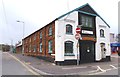
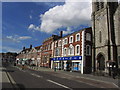
Historic Building in Cowper Street
This building is clearly very old and may once have been a small factory. The old petrol pump to the right of the black door suggests it was a garage at one time. It is now used by a home improvement company.
Image: © mike smith
Taken: 8 Apr 2012
0.05 miles
2
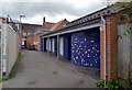
Public Toilets, Dereham
These toilets are on an alley off the Market Place.
Image: © habiloid
Taken: 23 Aug 2021
0.07 miles
3
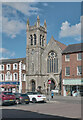
Dereham : Cowper Congregational Church
Grade II listed - built in the 1870s to a design by architect Edward Boardman : https://historicengland.org.uk/listing/the-list/list-entry/1077089?section=official-list-entry.
Image: © Jim Osley
Taken: 20 Aug 2023
0.07 miles
5
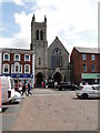
East Dereham Congregational church
Unfortunately, despite the potential gifts from a multitude of holidaymakers the church was well and truly bolted against visitors and parishioners alike.
Image: © Adrian S Pye
Taken: 15 Aug 2015
0.08 miles
6
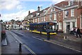
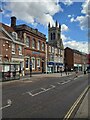
Market Place, Dereham
A Konectbus for Fakenham waits in the elegant market place at the heart of this mid-Norfolk town.
Image: © Stephen McKay
Taken: 4 Nov 2011
0.09 miles
8
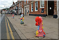
Knitted bollard covers, Market Place, Dereham
These can be seen in context in Image
Image: © habiloid
Taken: 23 Aug 2021
0.09 miles
9
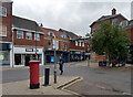
Junction of High Street and Church Street, Dereham
A close-up of the post box can be seen in Image
Image: © habiloid
Taken: 23 Aug 2021
0.09 miles
10
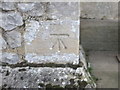
Ordnance Survey Cut Mark
This can be found on the wall of Dereham Congregational Church.
For more detail see : http://www.bench-marks.org.uk/bm63173
Image: © Peter Wood
Taken: 13 Nov 2014
0.09 miles