
IMAGES TAKEN NEAR TO
Kings Road, DEREHAM, NR19 2AG
Introduction
This page details the photographs taken nearby to Kings Road, NR19 2AG by members of the Geograph project.
The Geograph project started in 2005 with the aim of publishing, organising and preserving representative images for every square kilometre of Great Britain, Ireland and the Isle of Man.

There are currently over 7.5m images from over14,400 individuals and you can help contribute to the project by visiting https://www.geograph.org.uk
Image Map
Images are licensed for reuse under creativecommons.org/licenses/by-sa/2.0
Notes
- Clicking on the map will re-center to the selected point.
- The higher the marker number, the further away the image location is from the centre of the postcode.
Image Listing (88 Images Found)
Images are licensed for reuse under creativecommons.org/licenses/by-sa/2.0
Image
Details
Distance
1
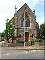
Trinity Methodist Church, Theatre Street
Image: © chris spencer
Taken: 1 Jul 2010
0.09 miles
2
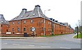
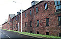
The Maltings
This is a huge double row of old maltings buildings. It has recently been converted into apartments, called The Maltings, with the basement becoming a car parking area.
Image: © mike smith
Taken: 8 Apr 2012
0.15 miles
3
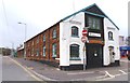
Historic Building in Cowper Street
This building is clearly very old and may once have been a small factory. The old petrol pump to the right of the black door suggests it was a garage at one time. It is now used by a home improvement company.
Image: © mike smith
Taken: 8 Apr 2012
0.15 miles
4
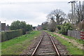
Track north of Dereham Station
A stretch of Single track between Neatherd road level crossing and Swanton road level crossing. Houses border the line, it is hoped in the next two years this section will be operational.
The trackbed here is private, I was on a supervised walking event.
Image: © Ashley Dace
Taken: 2 Apr 2010
0.15 miles
5
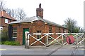
Level Crossing and Gate Keeper's Cottage
This is on Neatherd Road. The very crossing over the heritage Mid Norfolk Railway is only in occasional use at present. Originally many level crossings were operated by a gate keeper who was provided with a home next to the crossing.
Image: © mike smith
Taken: 8 Apr 2012
0.15 miles
6
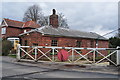
Neatherd Road Level Crossing
The Crossing house, in MNR ownership. It was restored with European funding several years ago.
The trackbed here is private, I was on a supervised walking event.
Image: © Ashley Dace
Taken: 2 Apr 2010
0.15 miles
9
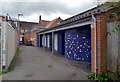
Public Toilets, Dereham
These toilets are on an alley off the Market Place.
Image: © habiloid
Taken: 23 Aug 2021
0.16 miles
10
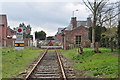
Neatherd Road Level Crossing
One of the only crossings on the line with original BR gates, however these need replacing. The old crossing house is still extant here, the maltings (now flats) can be seen in the distance.
The trackbed here is private, I was on a supervised walking event.
Image: © Ashley Dace
Taken: 2 Apr 2010
0.17 miles