
IMAGES TAKEN NEAR TO
Dereham Road, DEREHAM, NR19 1QU
Introduction
This page details the photographs taken nearby to Dereham Road, NR19 1QU by members of the Geograph project.
The Geograph project started in 2005 with the aim of publishing, organising and preserving representative images for every square kilometre of Great Britain, Ireland and the Isle of Man.

There are currently over 7.5m images from over14,400 individuals and you can help contribute to the project by visiting https://www.geograph.org.uk
Image Map
Images are licensed for reuse under creativecommons.org/licenses/by-sa/2.0
Notes
- Clicking on the map will re-center to the selected point.
- The higher the marker number, the further away the image location is from the centre of the postcode.
Image Listing (12 Images Found)
Images are licensed for reuse under creativecommons.org/licenses/by-sa/2.0
Image
Details
Distance
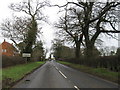
2
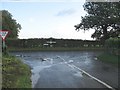
Church Road Junction
With the B1135 Dereham Road.
Image: © Roger Gilbertson
Taken: 1 Nov 2006
0.16 miles
3
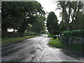
The Road To Wymondham
The B1135 at Whinburgh
Image: © Roger Gilbertson
Taken: 1 Nov 2006
0.16 miles
4

Farmland between the mid-Norfolk Railway and the B1135
The distant houses are on the southern edge of Whinburgh, at the junction of Dereham Road and Church Road.
Image: © Christine Johnstone
Taken: 23 May 2018
0.19 miles
5

Dereham Road between Garvestone and Whinburgh
Image: © Adrian S Pye
Taken: 26 Feb 2019
0.20 miles
6
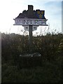
Village Sign
Village Sign at Whinburgh, Norfolk
Image: © Craig Tuck
Taken: 21 Feb 2009
0.21 miles
7
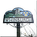
Whinburgh village sign
The sign which bears the same elements of the earlier example https://www.geograph.org.uk/photo/1181132 is now double-sided. https://www.geograph.org.uk/photo/7129271
The church of All Saints forms the background. The arms are those of the Bardolfs of Wormegay, lords of Whinburgh manor for almost 300 years. The plough is representing the reliance on agriculture as the main industry and the gorse or 'whin' is where the village derives its name.
The Bardolf name is closely associated with a delicious ancient recipe for Malepigernout, a spiced chicken porridge to be served upon the Coronation of the Monarch of England.
Image: © Jane Rackham
Taken: 26 Mar 2022
0.21 miles
8
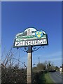
Whinburgh village sign
The sign which bears the same elements of the earlier example https://www.geograph.org.uk/photo/1181132 is now double-sided. https://www.geograph.org.uk/photo/7129269
The church of All Saints forms the background. The arms are those of the Bardolfs of Wormegay, lords of Whinburgh manor for almost 300 years. The plough is representing the reliance on agriculture as the main industry and the gorse or 'whin' is where the village derives its name.
The Bardolf name is closely associated with a delicious ancient recipe for Malepigernout, a spiced chicken porridge to be served upon the Coronation of the Monarch of England.
Image: © Jane Rackham
Taken: 26 Mar 2022
0.21 miles
9

The B1135
Between Whinburgh and Garvestone; also known as Dereham Road.
Image: © Roger Gilbertson
Taken: 1 Nov 2006
0.23 miles
10

Whinburgh Trout Lake Entrance
Puzzlingly, a notice said "No Fishing".
Image: © Roger Gilbertson
Taken: 1 Nov 2006
0.23 miles