IMAGES TAKEN NEAR TO
Westfield Road, DEREHAM, NR19 1JB
Introduction
This page details the photographs taken nearby to Westfield Road, NR19 1JB by members of the Geograph project.
The Geograph project started in 2005 with the aim of publishing, organising and preserving representative images for every square kilometre of Great Britain, Ireland and the Isle of Man.

There are currently over 7.5m images from over14,400 individuals and you can help contribute to the project by visiting https://www.geograph.org.uk
Image Map
Images are licensed for reuse under creativecommons.org/licenses/by-sa/2.0
Notes
- Clicking on the map will re-center to the selected point.
- The higher the marker number, the further away the image location is from the centre of the postcode.
Image Listing (6 Images Found)
Images are licensed for reuse under creativecommons.org/licenses/by-sa/2.0
Image
Details
Distance
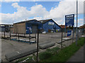

5
For All Your Steel Needs
A business in the modern industrial estate on the south side of Dereham, beside Charles Wood Road.
Image: © Mary and Angus Hogg
Taken: 24 Jun 2017
0.21 miles
6
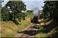
The first train of the day
An immaculate 9466 tank engine pulling the first train of the day to Wymondham along the Mid Norfolk Railway line at Toftwood.
Image: © Bill Sibley
Taken: 8 Aug 2009
0.23 miles