IMAGES TAKEN NEAR TO
Church Street, DEREHAM, NR19 1DW
Introduction
This page details the photographs taken nearby to Church Street, NR19 1DW by members of the Geograph project.
The Geograph project started in 2005 with the aim of publishing, organising and preserving representative images for every square kilometre of Great Britain, Ireland and the Isle of Man.

There are currently over 7.5m images from over14,400 individuals and you can help contribute to the project by visiting https://www.geograph.org.uk
Image Map
Images are licensed for reuse under creativecommons.org/licenses/by-sa/2.0
Notes
- Clicking on the map will re-center to the selected point.
- The higher the marker number, the further away the image location is from the centre of the postcode.
Image Listing (185 Images Found)
Images are licensed for reuse under creativecommons.org/licenses/by-sa/2.0
Image
Details
Distance
1
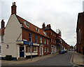
Old Government Buildings
Old government buildings in Church Street Dereham, Norfolk.
Image: © Keith Evans
Taken: 28 Dec 2013
0.01 miles
2
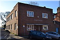
Quebec Street, Dereham
The offices of estate agents Case & Dewing which were the buildings of the drill hall of the 5th Battalion, Norfolk Regiment, the Norfolk Yeomanry (C Squadron), and 2 East Anglian Field Ambulances during World War 1. The building was one of several in the town, which were damaged by bombing by a Zeppelin on 8th September 1915.
Image: © Peter Barr
Taken: 30 Apr 2015
0.02 miles
3
Quebec Street, Dereham (2)
The offices of estate agents Case & Dewing which were the buildings of the drill hall of the 5th Battalion, Norfolk Regiment, the Norfolk Yeomanry (C Squadron), and 2 East Anglian Field Ambulances during World War 1. The building was one of several in the town, which were damaged by bombing by a Zeppelin on 8th September 1915.
Image: © Peter Barr
Taken: 30 Apr 2015
0.02 miles
4
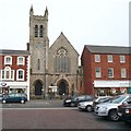
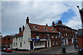
Congregational Church, Market Place, East Dereham
Designed by E Boardman and built in 1874 (Pevsner).
Image: © Humphrey Bolton
Taken: 28 Oct 2008
0.02 miles
5
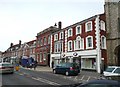
Barclays and Boots, Market Place, East Dereham
The Boots building might have been two houses, and is rather spoiled by the painted quoins, which look too prominent. The bank was probably purpose-built, and the next building was the Assembly Room, built in 1756, and of the buildings in this street was Pevsner's favourite.
Image: © Humphrey Bolton
Taken: 28 Oct 2008
0.02 miles
8
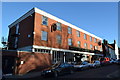
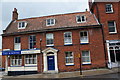
The Romany Rye
The Romany Rye hotel at Dereham, Norfolk. For info on its history see http://www.geograph.org.uk/photo/3794958
Image: © Keith Evans
Taken: 28 Dec 2013
0.03 miles
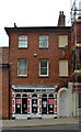
9
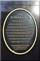
Plaque
Plaque outside The Romany Rye hotel at Dereham, Norfolk. For view of the hotel see http://www.geograph.org.uk/photo/3794946
Image: © Keith Evans
Taken: 28 Dec 2013
0.03 miles