IMAGES TAKEN NEAR TO
Deopham Road, WYMONDHAM, NR18 9TS
Introduction
This page details the photographs taken nearby to Deopham Road, NR18 9TS by members of the Geograph project.
The Geograph project started in 2005 with the aim of publishing, organising and preserving representative images for every square kilometre of Great Britain, Ireland and the Isle of Man.

There are currently over 7.5m images from over14,400 individuals and you can help contribute to the project by visiting https://www.geograph.org.uk
Image Map
Images are licensed for reuse under creativecommons.org/licenses/by-sa/2.0
Notes
- Clicking on the map will re-center to the selected point.
- The higher the marker number, the further away the image location is from the centre of the postcode.
Image Listing (13 Images Found)
Images are licensed for reuse under creativecommons.org/licenses/by-sa/2.0
Image
Details
Distance
1
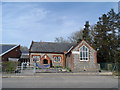
Morley primary school
Note the banner (blue) (on the fencing) with positive quotes from the last OFSTED inspection. Who ever is making these things must be doing very good business.
Image: © Bikeboy
Taken: 13 Apr 2015
0.01 miles
2
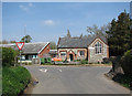
Morley CE Primary School
On Deopham Road; viewed from St Peter's Hill.
Image: © Evelyn Simak
Taken: 21 Apr 2008
0.01 miles
6
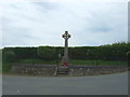
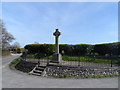
Morley War Memorial
Nine men were lost in WW1 and a further eight in WW2.
Image: © Adrian S Pye
Taken: 10 Jun 2015
0.03 miles
8
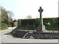
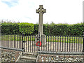
War Memorial
The war memorial at the junction of St Peter's Hill with Deopham Road; the view is easterly.
Image: © Evelyn Simak
Taken: 21 Apr 2008
0.03 miles
10
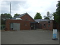
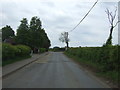
Morleyfield Lane
This lane goes down from 'High Oak'.
Image: © Jessica Aidley
Taken: 15 Dec 2003
0.13 miles