IMAGES TAKEN NEAR TO
Burnthouse Lane, WYMONDHAM, NR18 9NR
Introduction
This page details the photographs taken nearby to Burnthouse Lane, NR18 9NR by members of the Geograph project.
The Geograph project started in 2005 with the aim of publishing, organising and preserving representative images for every square kilometre of Great Britain, Ireland and the Isle of Man.

There are currently over 7.5m images from over14,400 individuals and you can help contribute to the project by visiting https://www.geograph.org.uk
Image Map
Images are licensed for reuse under creativecommons.org/licenses/by-sa/2.0
Notes
- Clicking on the map will re-center to the selected point.
- The higher the marker number, the further away the image location is from the centre of the postcode.
Image Listing (8 Images Found)
Images are licensed for reuse under creativecommons.org/licenses/by-sa/2.0
Image
Details
Distance
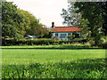
2
Crossroads in Silfield
The cottage seen in the background is The Compasses, a former public house.
Image: © Evelyn Simak
Taken: 23 Sep 2011
0.05 miles
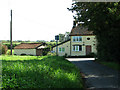
3
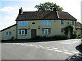
The Compasses, Silfield
A former public house by the crossroads.
Image: © Evelyn Simak
Taken: 23 Sep 2011
0.05 miles
5
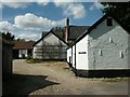
Lime Trees Farm, near Silfield
Part of a small settlement at the junction of Compass Road and Burnthouse Lane, effectively a dead end since the construction of the A11 trunk road.
Image: © Katy Walters
Taken: 29 Aug 2005
0.11 miles
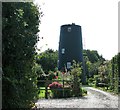
6
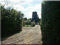
Old mill, near Silfield
Adjacent to Lime Trees Farm.
Image: © Katy Walters
Taken: 29 Aug 2005
0.11 miles