IMAGES TAKEN NEAR TO
Wattlefield, WYMONDHAM, NR18 9LA
Introduction
This page details the photographs taken nearby to NR18 9LA by members of the Geograph project.
The Geograph project started in 2005 with the aim of publishing, organising and preserving representative images for every square kilometre of Great Britain, Ireland and the Isle of Man.

There are currently over 7.5m images from over14,400 individuals and you can help contribute to the project by visiting https://www.geograph.org.uk
Image Map
Images are licensed for reuse under creativecommons.org/licenses/by-sa/2.0
Notes
- Clicking on the map will re-center to the selected point.
- The higher the marker number, the further away the image location is from the centre of the postcode.
Image Listing (7 Images Found)
Images are licensed for reuse under creativecommons.org/licenses/by-sa/2.0
Image
Details
Distance
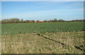
1
Paddock and Farm buildings, Wattlefield
Image: © Ian Robertson
Taken: 23 Feb 2007
0.02 miles
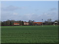
2
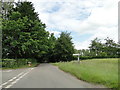
Wattlefield Road at the turn-off to Guiler's Lane
Image: © Adrian S Pye
Taken: 16 Jun 2019
0.09 miles
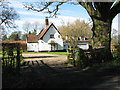
3
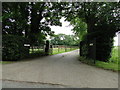
Entrance drive to Church Farm, Wattlefield
Image: © Adrian S Pye
Taken: 16 Jun 2019
0.10 miles
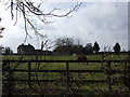
4
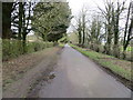
Hedge and tree-lined Wattlefield Road
Looking northward from near to Church Farm.
Image: © Peter Wood
Taken: 26 Feb 2020
0.14 miles