IMAGES TAKEN NEAR TO
Preston Avenue, WYMONDHAM, NR18 9JE
Introduction
This page details the photographs taken nearby to Preston Avenue, NR18 9JE by members of the Geograph project.
The Geograph project started in 2005 with the aim of publishing, organising and preserving representative images for every square kilometre of Great Britain, Ireland and the Isle of Man.

There are currently over 7.5m images from over14,400 individuals and you can help contribute to the project by visiting https://www.geograph.org.uk
Image Map
Images are licensed for reuse under creativecommons.org/licenses/by-sa/2.0
Notes
- Clicking on the map will re-center to the selected point.
- The higher the marker number, the further away the image location is from the centre of the postcode.
Image Listing (7 Images Found)
Images are licensed for reuse under creativecommons.org/licenses/by-sa/2.0
Image
Details
Distance
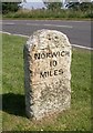
1
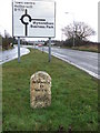
To Norwich 10
Old milestone Wymondhan, Norfolk for view of the other side see http://www.geograph.org.uk/photo/1156652. For more info on the stone see http://milestones.megalithia.com/sites/tg101007.htm do take a look at their home page.
This is one of a series of mileposts that follow the A11 see http://www.geograph.org.uk/search.php?i=5498676
Image: © Keith Evans
Taken: 10 Feb 2009
0.15 miles
2
Old Milestone
Old milestone Wymondhan, Norfolk for view of the other side see http://www.geograph.org.uk/photo/1156646 For more info on the stone see http://milestones.megalithia.com/sites/tg101007.htm do take a look at their home page.
Image: © Keith Evans
Taken: 10 Feb 2009
0.15 miles
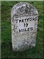
3
Old Milestone by the B1172, London Road, Wymondham Parish
Carved stone post by the B1172, in parish of WYMONDHAM (SOUTH NORFOLK District), London Road, by No. 48, on the verge, between the access road and the B1172. Thetford wedge, erected by the Thetford (to Norwich) turnpike trust in the 19th century.
Inscription reads:-
: NORWICH / 10 / MILES : : THETFORD / 19 / MILES :
Norfolk HER.
NHER Number: 56351 https://www.heritagegateway.org.uk/Gateway/Results_Single.aspx?uid=MNF62762&resourceID=1002
Milestone Society National ID: NO_NT10.
Image: © M Hallett
Taken: 18 Jan 2004
0.15 miles
4
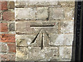
Benchmark Cavick House
There is a clear cut mark Image on the left hand gatepost of Cavick House, which is a working farm as well as a cafe.
Image: © Neville Goodman
Taken: 8 Aug 2017
0.18 miles
5
A clear cut mark
This clear mark is on a gatepost of Cavick House (STO P ENT CAVICK HO NW SIDE CAVICK RD) Image
Image: © Neville Goodman
Taken: 8 Aug 2017
0.21 miles
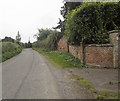
6
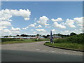
Chestnut Drive, Wymondham Business Park
Image: © Adrian S Pye
Taken: 6 Jun 2019
0.22 miles
7
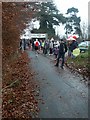
Road Race, Wymondham
The finish of the annual New Year's Day 10km road race, on Lady's Lane. Over 300 hardy souls turned out for the 11am start - the stragglers (including this geonerd) were heading in about noon.
Image: © Katy Walters
Taken: 1 Jan 2006
0.22 miles