IMAGES TAKEN NEAR TO
Magpie Place, WYMONDHAM, NR18 9FU
Introduction
This page details the photographs taken nearby to Magpie Place, NR18 9FU by members of the Geograph project.
The Geograph project started in 2005 with the aim of publishing, organising and preserving representative images for every square kilometre of Great Britain, Ireland and the Isle of Man.

There are currently over 7.5m images from over14,400 individuals and you can help contribute to the project by visiting https://www.geograph.org.uk
Image Map
Images are licensed for reuse under creativecommons.org/licenses/by-sa/2.0
Notes
- Clicking on the map will re-center to the selected point.
- The higher the marker number, the further away the image location is from the centre of the postcode.
Image Listing (13 Images Found)
Images are licensed for reuse under creativecommons.org/licenses/by-sa/2.0
Image
Details
Distance
1
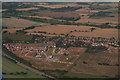
New development south of Wymondham: aerial 2017
Image: © Chris
Taken: 1 Sep 2017
0.05 miles
2
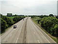
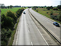
A11 Wymondham bypass looking towards Attleborough
From the footbridge. https://www.geograph.org.uk/photo/6190014
Image: © Adrian S Pye
Taken: 23 Jun 2019
0.09 miles