IMAGES TAKEN NEAR TO
Barnham Broom Road, WYMONDHAM, NR18 0RT
Introduction
This page details the photographs taken nearby to Barnham Broom Road, NR18 0RT by members of the Geograph project.
The Geograph project started in 2005 with the aim of publishing, organising and preserving representative images for every square kilometre of Great Britain, Ireland and the Isle of Man.

There are currently over 7.5m images from over14,400 individuals and you can help contribute to the project by visiting https://www.geograph.org.uk
Image Map
Images are licensed for reuse under creativecommons.org/licenses/by-sa/2.0
Notes
- Clicking on the map will re-center to the selected point.
- The higher the marker number, the further away the image location is from the centre of the postcode.
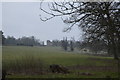
Image Listing (6 Images Found)
Images are licensed for reuse under creativecommons.org/licenses/by-sa/2.0
Image
Details
Distance
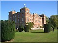
1
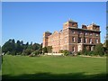
Kimberley House
Viewed from the south.
Built c.1712 to designs by William Talman (also the architect of Chatsworth and Buckingham House - now Palace), towers added c.1750.
Image: © Gareth Hughes
Taken: 29 Sep 2011
0.03 miles
2
Kimberley House
Grade II* listed. http://www.britishlistedbuildings.co.uk/en-386071-kimberley-house-including-service-wings-#.VTevMPAYFnk
Image: © N Chadwick
Taken: 18 Jan 2015
0.03 miles
3
Kimberley House
Grade II* listed. http://www.britishlistedbuildings.co.uk/en-386071-kimberley-house-including-service-wings-#.VTevMPAYFnk
Image: © N Chadwick
Taken: 18 Jan 2015
0.03 miles
4
Kimberley House
Garden Front. Designed by William Talman, c.1712, the towers at the corners were added in the mid 1700s. Rescued from near-dereliction in the 1950s.
Image: © Gareth Hughes
Taken: 29 Sep 2011
0.04 miles